Item details: An Accurate Map of the County Palatine of Chester
£ 375.00
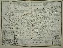
BOWEN, Emanuel & KITCHIN, Thomas.
An Accurate Map of the County Palatine of Chester
Imprint: London, 1753-[c.64]
54 x 70 cms., early ourline colour. A lovely fresh example.
Arguably the finest English county map of the eighteenth century from ' The Large English Atlas'. Thomas Kitchin was one of the most notable English cartographers of the eighteenth century. He was both an engraver and publisher of considerable reputation who was made Hydrographer to King George III. He worked with many of his contemporaries on various projects. This map of Cheshire is Hodson's state e, or 5 of 6, with the imprints of John and Carington Bowles and Robert Sayer. Hodson 221 pp. 97-147; Shirley 'Atlases in the BL' T-Bow 3a.