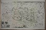
Item details: A Modern Map of the Island of Jersey
£ 125.00
ELLIS, Joseph
A Modern Map of the Island of Jersey
Imprint: London, c.1760
240 x 385 mm., with folds as issued, in good condition.
Joseph Ellis (fl.1750-d.1796) was an engraver whose most important cartographic production was the atlas named after him of the English Counties. It was first published in 1765 as the 'New English Atlas' of which only one incomplete example survives. The plates were engraved in the style of Thomas Kitchin as seen in the latter's 'England Illustrated' of 1764. Those plates which bear no engravers imprint are accepted to be engraved by him including this example of the Channel Islands. Hodson no. 238; Kingsley 44.