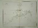
Item details: Chart of the Northern Part of the Bay of Bengal Laid down Chiefly from the Surveys Made by Bartholomew Plaisted and John Ritchie
£ 350.00
DALRYMPLE, Alexander
Chart of the Northern Part of the Bay of Bengal Laid down Chiefly from the Surveys Made by Bartholomew Plaisted and John Ritchie
Imprint: Paris, 1775
46 x 59 cms., early wash colour
William Herbert's "New Directory for the East Indies" was encouraged by the East India Company and first published in 1758. It quickly became the de-facto atlas of the region taking over prime place from the Third Part of the English Pilot which by then was over 50 years old. Further editions appeared in 1759, 1767 and 1776. It is in this latter edition that numerous new charts were included, many based on the highly talented Alexander Dalrymple who worked for the East India Company from 1752 and became its first Hydrographer in 1779. Cook Imago Mundi 33 pp. 46-64; Shirley "Atlases in the British Library" M.Dal 11a n.10; M.Herb1c 23.