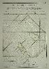
Item details: Plan de la Rade D'Achem et des Isles Circonvoisines
£ 175.00
D'APRES DE MANNEVILLETTE, Jean B. P. D.
Plan de la Rade D'Achem et des Isles Circonvoisines
Imprint: Paris, 1745
560 x 410 mm., fine early wash colour. Good condition.
A nice detailed chart of the coast of Sumatra or Indonesia centred on BANDA ACEH, the scene of the devastating tsunami which struck the region on 26 December 2004. The material collected for 'Le Neptune Oriental' was approved by the French Compagnie des Indes. D'Apres de Mannevillette was one of the first Hydrographers of France and an accomplished navigator. Born in Le Havre to a captain in the French West India Company he made a voyage to the Caribbean in 1726. He showed an early interest in navigation and was one of the first Frenchmen to use Hadley's quadrant and was later in life a friend of Dalrymple. Upon the atlas' publication it was highly commended by everyone. Updated at various times after initial publication in 1745 it was expanded considerably in 1775. NMM 203 no. 11; Shirley M.Apr 1c.