Item details: Carte de L'Extremite Meridionale de L'Amerique
£ 150.00
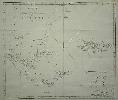
COOK, Captain James
Carte de L'Extremite Meridionale de L'Amerique
Imprint: Paris, 1775
455 x 520 mm., small foxmark in lower margin away from the image, upper right side margin cut close to facilitate binding, replaced, with folds as issued in the book, in good condition on thick paper.
This find large scale sea chart of the southern tip of South America and the Falkland Islands comes from the French edition of Captain James Cook's voyage around the world entitled 'Voyage dans l'Hemisphere Australe et autour du Monde'. An inset lower right focuses on New Years Island and nearby harbour on Staten Island at the tip of Tierra del Fuego. The whole is engraved by Benard. Sabin 16249.