Item details: Alsatia Landgraviatus, cum Suntgoia et Brisgoia
£ 275.00
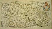
BLAEU, Willem
Alsatia Landgraviatus, cum Suntgoia et Brisgoia
Imprint: Amsterdam, 1638
400 x 800 mm., early outline colour, two sheets joined, as issued, in good condition.
This large two-sheet map of the Alsace region of present day France is based on the work of Gerard Mercator. It first appeared in the 'Atlas Novus' just before Willem Blaeu's death in 1638. It covers the region from Granville and Sarburg in the north and from Basel to Landaw in the south. It includes also the Rhine River. It is oriented to the west, the whole being decorated with an attractive title cartouche bearing two figures and a coast of arms. French text on verso. Koeman I Bl 139; Van der Krogt, P. (Atlantes) 2520:2.