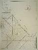
Item details: Carte de la Cote Occidentale de l'Isle Sumatra depuis la Ligne Equinoctiale jusqu'au Detroit de la Sonde
£ 125.00
D'APRES DE MANNEVILLETTE, Jean Baptiste P. D.
Carte de la Cote Occidentale de l'Isle Sumatra depuis la Ligne Equinoctiale jusqu'au Detroit de la Sonde
Imprint: Paris, 1775
660 x 480 mm., in good condition.
A good large scale chart of the south west of Sumatra in Indonesia. It covers the territory from the Straits of Sunda past Bengkulu further north. The material collected for 'Le Neptune Oriental' was approved by the French Compagnie des Indes. D'Apres de Mannevillette was one of the first Hydrographers of France and an accomplished navigator. Born in Le Havre to a captain in the French West India Company he made a voyage to the Caribbean in 1726. He showed an early interest in navigation and was one of the first Frenchmen to use Hadley's quadrant and was later in life a friend of Dalrymple. Upon the atlas' publication it was highly commended by everyone. Updated at various times after initial publication in 1745 it was expanded considerably in 1775 when this chart was introduced. NMM 204 not listed; Shirley M.Apr 1c.