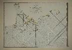
Item details: Carte d'une partie Des Cotes De La Chine et des Isles adjacentes ...
£ 2500.00
D'APRES DE MANNEVILLETTE, Jean Baptiste P. D.
Carte d'une partie Des Cotes De La Chine et des Isles adjacentes ...
Imprint: Paris, 1775
335 x 485 mm., in fine modern wash colour, in good condition.
A highly important chart depicting the FIRST RECOGNISABLE CARTOGRAPHIC REPRESENTATION OF HONG KONG after the work of Alexander Dalrymples in 1771. We could find no record of the original Dalrymple chart having been on the market in recent memory. This therefore is the earliest obtainable printed map to depict Hong Kong. It is based upon the surveys and soundings made from the navigational surveys in 1754, 1759, and 1760 by Dalrymple (1737-1808) the highly talented Scottish hydrographer who worked for the East India Company from 1752 and became its first Hydrographer in 1779. In 1795 he was promoted to Hydrographer to the Royal Navy. Dalrymple is renowned for the work he put in to correlating old charts with new discoveries in the East.At this point in time the only Chinese port open to European trade was Canton, the approaches to which are depicted here. The Portuguese colony of Macao, founded in 1557, is seen in the west. The nearby anchorage at Typti was a popular waypoint for vessels. At the top of the map is the Gueule du Tigre, Boca Tigris or tigers mouth, the entrance to the Canton River. The now famous port and city of Hong Kong did not exist at this point not being founded until 1841. It is depicted here as Fanchin Chow (Victoria Island) with both Stanley and DAgular peninsulas shown in outline. Both Lantao and Lamma Islands are identified.This chart was published by Dalrymples friend Jean-Baptiste DApres de Mannevillette in the Neptune Orientale. The material collected for it was approved by the French Compagnie des Indes. DApres de Mannevillette was one of the first Hydrographers of France and an accomplished navigator. Born in Le Havre to a captain in the French West India Company he made a voyage to the Caribbean in 1726. He showed an early interest in navigation and was one of the first Frenchmen to use Hadleys quadrant and was later in life a friend of Dalrymple. Upon the atlas publication it was highly commended by everyone. Updated at various times after initial publication in 1745, it was expanded considerably in 1775 when this chart was introduced. Howse & Sanderson (1973) no. XLI; Sanderson (1971) 204 no. 55; Shirley (2004) M.Apr 1c.