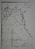
Item details: Carte de la Cote Orientale du Golfe de Bengale
£ 150.00
D'APRES DE MANNEVILLETTE, Jean Baptiste P. D.
Carte de la Cote Orientale du Golfe de Bengale
Imprint: Paris, 1745
480 x 330 mm., with one or two light marks lower right, just into the image, otherwise in good condition.
A nice chart of the northern portion of the Gulf of Bengal depicting in the north Luckipore and Islamabad. The material collected for 'Le Neptune Oriental' was approved by the French Compagnie des Indes. D'Apres de Mannevillette was one of the first Hydrographers of France and an accomplished navigator. Born in Le Havre to a captain in the French West India Company he made a voyage to the Caribbean in 1726. He showed an early interest in navigation and was one of the first Frenchmen to use Hadley's quadrant and was later in life a friend of Dalrymple. Upon the atlas' publication it was highly commended by everyone. Updated at various times after initial publication in 1745 it was expanded considerably in 1775. NMM 203 no. 9; Shirley M.Apr 1c.