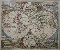
485 x 580 mm., early wash colour, with lower centrefold split and smaller nearby tear into the image repaired, area of light foxing lower right, otherwise in good condition.
Sometime after 1684 the firm of Danckerts were granted a privilege protecting their works. Soon after Justus Danckerts published this attractive double hemisphere world map. California is depicted with a double bay northern shore and above that is Terra Esonis the confused coastline common amongst cartographers of the day. New Guinea is depicted as an island with the York Peninsula below it, the remainder of Hollandia Nova is found on the eastern hemisphere. The whole is finished with polar hemispheres top and bottom and attractive allegorical scenes in the four corners. There is only one recorded state of the plate. It is unclear which Justus Danckerts was responsible for the plate, father or son. Provenance: private English collection since 1978. Shirley (1984) 529.