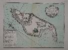
Item details: Plan de L'Isle de Gore Avec ses Fortifications
£ 120.00
BELLIN, Jacques Nicolas
Plan de L'Isle de Gore Avec ses Fortifications
Imprint: Paris, 1764
200 x 265 mm., early wash colour in good condition.
An attractive map of the island of Goree, a small island of just 45 acres (0.2 sq. km.) located only 2 km at sea from the main harbour of Dakar, Senegal. It was first occupied by the Portuguese c.1450 as a post to enable further southward exploration down the coast of Africa. In turn it became a Dutch, French and English possession. It is from Jacques Nicolas Bellin's greatest atlas, the 'Petit Atlas Maritime'. This copperplate engraved chart shows the whole island in detail. The rococo-style title cartouche bears a distance scale. Phillips 638 & 3508; Shirley BL M. Bell 5a; Nordenskiold Collection 1 no. 10; Maritime Museum no. 211.