Item details: Carte Nouvelle des Costes D'Angleterre depuis la Riviere de la Tamise jusques a Portland …
£ 4950.00
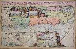
DE HOOGHE, Romain
Carte Nouvelle des Costes D'Angleterre depuis la Riviere de la Tamise jusques a Portland …
Imprint: Amsterdam, 1693
580 x 940 mm., two sheets joined, in fabulous early wash colour, royal coat of arms and cities heightened in gold, minor centrefold split just into the lower part of the image, otherwise in excellent condition.
In 1692 Pierre Mortier had published a Dutch contrefaçon of the 'Atlas Nouveau' by Alexis-Hubert Jaillot. It was issued in partnership with Pierre Huguetan, a French bookseller resident in Amsterdam, who provided considerable financial backing. Their next project was an edition of Jaillots 'Neptune François', first published in 1693. For this Mortier employed the finest engravers and extended the work with the magnificent 'Cartes Marines à lusage du Roy de la Grande Bretagne'. It contained only nine charts, eight of which were of British waters. They are engraved by Romain de Hooghe, who was in the employ of William III at the time, and are arguably the most stunning sea charts produced to date (Burden). Few great artists have turned their hands to mapmaking Romeyn de Hooghe was an exception to the pattern. A celebrated artist from the late seventeenth century, he was responsible for a volume of nine sea charts (Campbell).This is one of only two plates that focus on the coasts of England; it extends from Kent in the east to Portland Bill in the west. The River Thames upriver to Kingston is clearly displayed. The map also extends southwards to take in the Channel Island of Alderney. A detailed inset centres on the Thames Estuary and an extremely ornate dedication cartouche to William III is flanked with fine views of Portsmouth and Rochester. It was issued just one year after the French planned invasion along the same coast. Burden (2007) p. 486; Campbell (1981) pl. 44; Koeman (1967-70) IV Mor E no. 7.