|
|
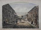
Imprint: Unknown, c.1840
230 x 310 mm., early coloured lithograph with ruled border, some light foxing upper left otherwise in good condition.
This very rare hand coloured lithograph of the High Street of Lutterworth is identified in pencil in the lower border. The title below has bee trimmed. A wonderful detailed look of the main thoroughfare illustrating the business and people of the day.
Stock number:8301.
|
|
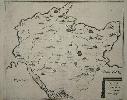
Imprint: (Germany), c.1720
345 x 415 mm., with folds as issued. In fine condition on good paper.
A finely engraved large scaled map of the region between Hamburg and Kiel. We have been unable to trace the origin of this map.
Stock number:4168.
|
|
|
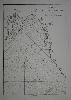
Imprint: New York, (Printed by Samuel Loudon, No. 5, Water-Street, between the Coffee-House and Old Slip), 24 November 1783
Inscription: Signed, Inscribed Or Annotated 270 x 155 mm., professionally lined with tissue, with loss of the last five lines and imprint, otherwise in good condition.
BROADSIDE POSTED IN NEW YORK DETAILING THE PROCESSION TO RE-OCCUPY THE CITY. Exceedingly rare, no example has been traced ever being on the open market.BackgroundNew York was lost to British forces in 1776, early in the American Revolution. The city became the British headquarters for the remainder of the campaign. Despite the surrender occurring at Yorktown on 19 October 1781. Whilst we look at Yorktown as the end of the war it was in fact not so clear. British forces remained in America, winter was fast approaching and neither side had the stomach for more conflict. This continued into 1782 without any clarity about any peace process. Eventually the American appointed commissioners John Adams, Benjamin Franklin, John Jay and Henry Laurens met in Paris in April 1782. The presence of the French and Spanish in the negotiations made it much more complicated. Ultimately John Jay approached the British Prime Minister Lord Shelburne directly. They both agreed that a mutually beneficial treaty would be better achieved by leaving the French and Spanish out of the negotiations. The final Treaty was signed in Paris on 3 September 1783.New YorkSir Guy Carleton oversaw the British forces in North America and in August 1783, he received orders from London to evacuate New York. The British withdrawal was complicated by the flood of loyalists pouring into the city. Over 29,000 of them were evacuated along with over 3,000 black loyalist former slaves. The latter was in violation of the Treaty which called for their return to former owners. Ultimately the final date was set for noon on 25 November 1783. As the date approached Carleton was still evacuating. A fleet of twenty vessels had been delayed in its return from Halifax due to inclement weather. Provisioning continued through the weekend in poor weather. On the 24 November with the weather improving a dispatch rider was sent north to McGowan�s Pass (now the north east corner of Central Park) where General Washington was encamped.25 November 1783The �Committee appointed to conduct the Order of receiving their Excellencies Governor Clinton and General Washington� laid out the events of the day. These had been �distributed widely on handbills. Poles, shop windows, hoardings, and even brick walls displayed the notices. There was no British interference� (Weintraub). This is an example of that very handbill or broadside. On the morning of the 25th Washington began marching down Broadway. The procession gathered at the �Bull�s Head, in the Bowery�, then on the outskirts of town. It is now approximately the junction of Canal and Bowery. The entry was delayed as Washington had stipulated that he would not enter the city until the British flag had been replaced at Fort George. The British had deliberately greased the pole to make it harder to remove. After several attempts a set of wooden cleats were cut and nailed to the pole with the help of a ladder. It was replaced by the Stars and Stripes. Citizens were invited to join the procession at the Bowling Green at the southern end of Broadway. TallmadgeThe Memoirs of Colonel Benjamin Tallmadge (1754-1835) recount the day well; �Gen. Knox, at the head of a select corps of American troops, entered the city as the rear of the British troops embarked; soon after which the Commander-in-Chief, accompanied by Gov. Clinton and their respective suites, made their public entry into the city on horseback � So perfect was the order of the march, that entire tranquillity prevailed, and nothing occurred to mar the general joy. Every countenance seemed to express the triumph of republican principles over the military despotism which had so long pervaded this now happy city � The joy of meeting friends, who had long been separated by the cruel rigours of war, cannot be described.�The time now drew near when the Commander-in-Chief intended to leave this part of the country for his believed retreat at Mount Vernon. On Tuesday, the 4th of December, it was made known to the officers then in New York, that Gen. Washington intended to commence his journey on that day. At 12 o�clock the officers repaired to Francis� Tavern, in Pearl Street, where Gen. Washington had appointed to meet them, and to take his final leave of them. We had been assembled but a few moments, when His Excellency entered the room. His emotion, too strong to be concealed, seemed to be reciprocated by every officer present. After partaking of a slight refreshment, in almost breathless silence, the General filled his glass with wine, and turning to the officers, he said: 'With a heart full of love and gratitude, I now take leave of you. I most devoutly wish that your latter days may be as prosperous and happy as your former ones have been glorious and honorable. I cannot come to each of you, but shall feel obliged if each of you will come and take me by the hand'�Gen. Knox being nearest to him, turned to the Commander-in-Chief, who, suffused in tears, was incapable of utterance, but grasped his hand; when they embraced each other in silence. In the same affectionate manner, every officer in the room marched up to, kissed, and parted with his General-in-Chief. Such a scene of sorrow and weeping I had never before witnessed, and I hope I may never be called upon to witness again� (Tallmadge).He returned to Baltimore where he formally resigned his commission and travelled on to Mount Vernon. His country would soon be calling again. To this day an Evacuation Day dinner is held there at which the same 13 toasts are recited.The BroadsideThe English Short Title Catalogue cites only four examples in institutions; John Carter Brown Library, the New York State Library and two examples at the Clements Library. One example in the Stokes� Collection is illustrated in �Iconography of Manhattan�, volume V p. 1102. One might presume that now resides at the New York Public Library. It is printed by Samuel Loudon (1727?-1813). Loudon had printed the New York State constitution in Fishkill, New York, 1777. He was the town�s Postmaster from 1777-83. This example lacks the last few lines but curiously matches that of the Facsimile of the 'Original in possession of Geo: Granville White, Brooklyn, N.Y. (grandson of Thos. Tucker)'. Tucker is named in the broadside.Provenance: William Thornton, architect of the Capitol Building; Comte de Volney (1757-1820); acquired 15 May 1984; Burden Collection. Bristol B5767; Dawson (January 1867) �The Historical Magazine, and Notes and Queries� pp. 44-5; ESTC W24689; Nebenzahl (1974) pp. Shipton and Mooney (??) no. 44426; Stokes (1915-28) vol. V pp. 1103, 1171-75; Tallmadge (1904) �Memoir of Colonel Benjamin Tallmadge� pp. 95-8; Weintraub (2003) �General Washington's Christmas Farewell: A Mount Vernon Homecoming, 1783�.
Stock number:9727.
|
|
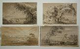
Imprint: 1813
160 x 290 mm. each on average, two laid on paper, in good condition.
The six pen and ink drawings are entitled as follows: �Southampton 1813�, �Isle of Wight. The Needles � Hirst Castle. View from Limmington Bay � Jany 1813�, �Southampton Water�, �Dibden Church New Forrest 1813�, �Southampton Water� and �Southampton water Calshot Castle Isle of Wight 1813�.
Stock number:6300.
|
|

Imprint: c.1830
95 x 280 mm. each, two watercolours, attached at the corners to a larger sheet of paper.
A pair of finely executed watercolours.
Stock number:8073.
|
|
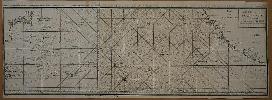
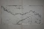
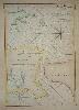
Imprint: Amsterdam, c.1750
870 x 300 mm., in two sheets, with folds as issued in the book but here ironed out. Minor paper crease and binders tear repaired, otherwise in good condition.
This two sheet chart details the route the Spanish galleons take between the Philippines and Acapulco, Mexico. The tracks of Commodore George Anson and Nostra Seigniora de Cabadonga are illustrated. The chart is found in the Dutch edition of the travels of Anson who left Britain in 1740 at the head of a fleet of six ships sent to attack Spanish colonial interests in South America. Within a year Anson fleet had been reduced to three ships and he had lost two thirds of his men. After resting in Juan Fernandes, he left on his flagship 'Centurion' in the hope of finding a heavily laden Spanish galleon. After such a poor start to the voyage they finally struck it rich capturing the Nuestra Se�ora de Cabadonga off Cape Espiritu Santo on June 20, 1743.
Stock number:7494.
|
|
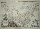
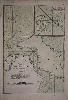
Imprint: The Hague, 1737
470 x 685 mm., in EARLY WASH COLOUR, small lower margin tear short of the image, repaired otherwise in very good condition.
This very attractive map of China and the Korean peninsula is from Jean Baptiste Du Halde�s account. The work was first published as the �Description Geographique � de la Chine� in Paris 1735, which was closely followed by this Dutch edition in 1737. Du Halde was a Jesuit priest and confessor to Louis XIV. For many years he studied the Jesuit reports being sent back to Paris and published this magnificent four volume work in 1735. The maps accompanying the work were produced by Jean Baptiste Bourguignon d�Anville the noted cartographer of the day. One of the main cartographic sources was the Chinese woodblock atlas known as the Kangxi which was completed 1718-19. This Dutch edition was issued as the �Nouvel Atlas de la Chine�. The book quickly became the principal cartographic authority on China in the eighteenth century.This map is decorated with a very elaborate pictorial title cartouche. It depicts the Emporer Kangxi presiding over the survey and two Fathers with a mounted armed escort investigating a farm settlement, his buildings and cattle. The scale cartouche is adorned by two wolf hunters. The whole is engraved by Gerard Kondet (Condet), one of a noted family of engravers. For this map�s production d�Anville (1697-1782) used ones prepared by Jesuit missionaries and commissioned by Emporer Kangxi who ordered a survey of the country in 1708-1716. The maps extends far enough to encompass all of modern day China taking in Tibet and Kashgar to the west, Mongous and in the north and Mantcheoux to the north east. Inner Mongolia and Manchuria are also depicted. The finished map is the first accurate cartographic depiction of the region available in the western world.It is also notable for recording the Korean peninsula with a level of accuracy for the first time. By the end of the seventeenth century much of China was mapped by western society but access to the Korean peninsula was strictly controlled. The Jesuits were obliged to rely on Chinese or Korean sources for information. �An agent of the Kangxi Emperor, referred to as the �Tartar lord�, sent on a diplomatic mission to Seoul, was able to take limited measurements surreptitiously. He obtained a copy of a Korean map from the imperial palace and [Father Jean-Baptiste] Regis later adjusted it with the agent�s geodetic observations. The resulting map of Korea became part of the comprehensive atlas of the Chinese Empire and surrounding territories produced for the emperor by the Jesuits. Known as the Kangxi atlas, it was issued several times in small printings in China and brought to Paris where Du Halde ...� (Nebenzahl).D�Anville is said to have produced his first map at the age 15 but it was his maps for Du Halde which gained him notoriety for the first time. In the developing tradition of French cartography they are renowned for their attention to detail and accuracy. D�Anville followed de L�Isle as cartographer to the King. His vast collection of cartographic material survives today. Chang 'China in European Maps' pl. 44; Nebenzahl 'Mapping Korea, a challenge to early mapmakers', in 'Mappae Antiquae Liber Amicorum Gunter Schilder' pp. 167-74; Shirley 'Atlases in the BL' T.Hald 3a no. 1; Yee 'Cartography in China' in 'The History of Cartography. Volume 2, Book 2'.
Stock number:5913.
|
|
Imprint: Paris, 1775
320 x 685 mm., in good condition on thick paper with large margins.
A fine map engraved by Guilaume De-la-Haye of the Guinea coast of West Africa. With an inset of the Gold Coast. It was published and drawn by Jean Baptiste Bourguignon d' Anville (1697-1782), a noted French cartographer who compiled over 200 maps.
Stock number:8240.
|
|
|
Imprint: Paris, 1754
500 x 810 mm. each, two sheets in early outline colour and in good condition.
A fine two sheet map of western Europe by the great French cartographer le Sieur D'Anville. D'Anville's career spanned much of the eighteenth century as he died in 1782 aged 84. He was renowned for his attention to detail continually updating his work. On his death his huge personal collection of some 9000 maps maps was acquired for the state and resides today in the Bibliotheque Nationale, Paris. This large detailed map includes an inset of the Faeroe and Shetland Islands upper left. Shirley (2004) T.Anv 2a 2 & 3.
Stock number:8121.
|
|
Imprint: Paris, 1753
52 x 108 cms., early outline colour in two sheets joined as issued. In very good condition
This fine large scale map of Tartary and Siberia was engraved by de la Fosse. Many of d'Anville's atlases are untitled collections of maps, an example including this map can be found in the British Library. D'Anville died in 1782 aged 84 having led an active life cartographically. He was a thorough editor of his maps, so much so that upon his death his collection of some 9000 maps was acquired by the state. Shirley BL T.Anv 2a no. 12
Stock number:4146.
|
|
Imprint: Paris, 1781
335 x 495 mm., in fine condition.
The Island of Diego Garcia is in the Chagos Group some 1,600 kilometres south of the tip of India. It is one of only five monitoring stations in the world for the Global Positioning System positioning system. It is still unclear after whom the island was named though the group first appears on the Pierre Descelier manuscript of 1550. The highly important Edward Wright printed world map of 1599 is the first to record Diego Garcia under its present name. From 1781 supplement to 'Neptune Oriental'. The material collected for 'Le Neptune Oriental' was approved by the French Compagnie des Indes. D'Apres de Mannevillette was one of the first Hydrographers of France and an accomplished navigator. Born in Le Havre to a captain in the French West India Company he made a voyage to the Caribbean in 1726. He show an early interest in Navigation and was one of the first Frenchmen to use Hadley's quadrant and was later in life a friend of Dalrymple. Upon the atlas' publication it was highly commended by everyone. NMM 203.
Stock number:4514.
|
|
Imprint: Paris, 1775
475 x 325 mm., in early outline colour, good condition.
A good large scale chart of the Nicobar Islands in the Indian Ocean. The material collected for 'Le Neptune Oriental' was approved by the French Compagnie des Indes. D'Apres de Mannevillette was one of the first Hydrographers of France and an accomplished navigator. Born in Le Havre to a captain in the French West India Company he made a voyage to the Caribbean in 1726. He showed an early interest in navigation and was one of the first Frenchmen to use Hadley's quadrant and was later in life a friend of Dalrymple. Upon the atlas' publication it was highly commended by everyone. Updated at various times after initial publication in 1745 it was expanded considerably in 1775 when this chart was introduced. NMM 204 no. 53; Shirley M.Apr 1c.
Stock number:5168.
|
|
Imprint: Paris, 1745
680 x 480 mm, with two small tears in the right margin, one just touching the neatline, both repaired otherwise in good condition.
A nice detailed chart of the coast of the Straits of Sunda with Sumatra to the upper left and Java, both in Indonesia. The important colonial port of Bantam is depicted on the north coast of Java. The inset lower left features a 'Plande la Baye de l'Isle de Mew ou Cantaye', a small island off the western coast of Java, in what today is the Ujung Kulon National Park. Three coastal profiles are inserted in Java. The material collected for 'Le Neptune Oriental' was approved by the French Compagnie des Indes. D'Apres de Mannevillette was one of the first Hydrographers of France and an accomplished navigator. Born in Le Havre to a captain in the French West India Company he made a voyage to the Caribbean in 1726. He showed an early interest in navigation and was one of the first Frenchmen to use Hadley's quadrant and was later in life a friend of Dalrymple. Upon the atlas' publication it was highly commended by everyone. Updated at various times after initial publication in 1745 it was expanded considerably in 1775. NMM 203 no. 15; Shirley M.Apr 1c.
Stock number:5535.
|
|
Imprint: Paris, 1775
660 x 480 mm., in good condition.
A good large scale chart of the south west of Sumatra in Indonesia. It covers the territory from the Straits of Sunda past Bengkulu further north. The material collected for 'Le Neptune Oriental' was approved by the French Compagnie des Indes. D'Apres de Mannevillette was one of the first Hydrographers of France and an accomplished navigator. Born in Le Havre to a captain in the French West India Company he made a voyage to the Caribbean in 1726. He showed an early interest in navigation and was one of the first Frenchmen to use Hadley's quadrant and was later in life a friend of Dalrymple. Upon the atlas' publication it was highly commended by everyone. Updated at various times after initial publication in 1745 it was expanded considerably in 1775 when this chart was introduced. NMM 204 not listed; Shirley M.Apr 1c.
Stock number:5536.
|
|
Imprint: Paris, 1775
335 x 485 mm., in fine modern wash colour, in good condition.
A highly important chart depicting the FIRST RECOGNISABLE CARTOGRAPHIC REPRESENTATION OF HONG KONG after the work of Alexander Dalrymple�s in 1771. We could find no record of the original Dalrymple chart having been on the market in recent memory. This therefore is the earliest obtainable printed map to depict Hong Kong. It is based upon the surveys and soundings made from the navigational surveys in 1754, 1759, and 1760 by Dalrymple (1737-1808) the highly talented Scottish hydrographer who worked for the East India Company from 1752 and became its first Hydrographer in 1779. In 1795 he was promoted to Hydrographer to the Royal Navy. Dalrymple is renowned for the work he put in to correlating old charts with new discoveries in the East.At this point in time the only Chinese port open to European trade was Canton, the approaches to which are depicted here. The Portuguese colony of Macao, founded in 1557, is seen in the west. The nearby anchorage at �Typti� was a popular waypoint for vessels. At the top of the map is the �Gueule du Tigre�, Boca Tigris or tiger�s mouth, the entrance to the Canton River. The now famous port and city of Hong Kong did not exist at this point not being founded until 1841. It is depicted here as �Fanchin Chow� (Victoria Island) with both Stanley and D�Agular peninsulas shown in outline. Both Lantao and Lamma Islands are identified.This chart was published by Dalrymple�s friend Jean-Baptiste D�Apres de Mannevillette in the �Neptune Orientale�. The material collected for it was approved by the French Compagnie des Indes. D�Apres de Mannevillette was one of the first Hydrographers of France and an accomplished navigator. Born in Le Havre to a captain in the French West India Company he made a voyage to the Caribbean in 1726. He showed an early interest in navigation and was one of the first Frenchmen to use Hadley�s quadrant and was later in life a friend of Dalrymple. Upon the atlas� publication it was highly commended by everyone. Updated at various times after initial publication in 1745, it was expanded considerably in 1775 when this chart was introduced. Howse & Sanderson (1973) no. XLI; Sanderson (1971) 204 no. 55; Shirley (2004) M.Apr 1c.
Stock number:6985.
|
|
Imprint: Paris, 1745
480 x 330 mm., with one or two light marks lower right, just into the image, otherwise in good condition.
A nice chart of the northern portion of the Gulf of Bengal depicting in the north Luckipore and Islamabad. The material collected for 'Le Neptune Oriental' was approved by the French Compagnie des Indes. D'Apres de Mannevillette was one of the first Hydrographers of France and an accomplished navigator. Born in Le Havre to a captain in the French West India Company he made a voyage to the Caribbean in 1726. He showed an early interest in navigation and was one of the first Frenchmen to use Hadley's quadrant and was later in life a friend of Dalrymple. Upon the atlas' publication it was highly commended by everyone. Updated at various times after initial publication in 1745 it was expanded considerably in 1775. NMM 203 no. 9; Shirley M.Apr 1c.
Stock number:7413.
|
|
Imprint: Paris, 1775
480 x 330 mm., modern outline colour, tear in lower left corner repaired, otherwise in good condition.
A good large scale chart of the east end of Java and the western part of Bali.. An inset lower left features a 'Plan de la Baye de Ballambouang'. The material collected for 'Le Neptune Oriental' was approved by the French Compagnie des Indes. D'Apres de Mannevillette was one of the first Hydrographers of France and an accomplished navigator. Born in Le Havre to a captain in the French West India Company he made a voyage to the Caribbean in 1726. He showed an early interest in navigation and was one of the first Frenchmen to use Hadley's quadrant and was later in life a friend of Dalrymple. Upon the atlas' publication it was highly commended by everyone. Updated at various times after initial publication in 1745 it was expanded considerably in 1775 when this chart was introduced. NMM 204 no. 55; Shirley M.Apr 1c.
Stock number:5819.
|
|
Imprint: Paris, 1745
560 x 410 mm., fine early wash colour. Good condition.
A nice detailed chart of the coast of Sumatra or Indonesia centred on BANDA ACEH, the scene of the devastating tsunami which struck the region on 26 December 2004. The material collected for 'Le Neptune Oriental' was approved by the French Compagnie des Indes. D'Apres de Mannevillette was one of the first Hydrographers of France and an accomplished navigator. Born in Le Havre to a captain in the French West India Company he made a voyage to the Caribbean in 1726. He showed an early interest in navigation and was one of the first Frenchmen to use Hadley's quadrant and was later in life a friend of Dalrymple. Upon the atlas' publication it was highly commended by everyone. Updated at various times after initial publication in 1745 it was expanded considerably in 1775. NMM 203 no. 11; Shirley M.Apr 1c.
Stock number:4940.
|
|
Imprint: Brussels, 1745-[75]
480 x 330 mm., early wash colour, with pasted over section containing new data on the north and east shores of Banca, in good condition.
A nice detailed chart of the coast of south east coast of Sumatra or Indonesia with the Island of Banca (Bangka) offshore. The material collected for 'Le Neptune Oriental' was approved by the French Compagnie des Indes. D'Apres de Mannevillette was one of the first Hydrographers of France and an accomplished navigator. Born in Le Havre to a captain in the French West India Company he made a voyage to the Caribbean in 1726. He showed an early interest in navigation and was one of the first Frenchmen to use Hadley's quadrant and was later in life a friend of Dalrymple. Upon the atlas' publication it was highly commended by everyone. Updated at various times after initial publication in 1745 it was expanded considerably in 1775. The inset upper right features a 'Petit Plan du Detroit a l'Est de Banca'. NMM 203 no. 18; Shirley M.Apr 1c.
Stock number:8375.
|
|
|
Imprint: London, Printed for, and Sold by the Author, and the Booksellers, 1 August 1776
Binding: Hardback Octavo (185 x 115 mm.), contemporary half calf, marbled paper boards, spine with raised bands, gilt ruled, with gilt red calf title, corners repaired, light wear. With general plan, engraved title, pp. 7, (1), 44 and 44 maps, with contemporary manuscript pagination, front free endpaper working loose, otherwise in good condition.
Mostyn John Armstrong (fl.1769-91) was the son of Andrew Armstrong, both were cartographers although only the son published any atlas. Their focus was on Scottish related material with the notable exception of three large scale county maps of Cambridgeshire, Lincolnshire and Norfolk. This is the second edition of this work, the date on the title page is altered to 1 August 1776, from 1 June, matching that of the dedication to Thomas Pennant on the following page. The title is expanded also with the insertion of ‘With the Country Three Miles, on each Side, Drawn on a Scale of Half an Inch to a Mile’, to promote the scale of the depiction. The ensuing preliminary leaves are also altered somewhat being reduced from 8 to 7 pages. The advert within the text for the map of Lincolnshire is replaced by an announcement of the availability of 'An Actual Survey of the Great Post-Road between London and Dover; With a general View of the Road to Paris' from December for 3s. The ‘Alphabetical Index of the Post-Towns’ is reduced from two pages to one, those towns within 3 miles of the route now deemed unnecessary to list.The plates themselves are also altered, now bearing the names of the main towns and cities across the top. A further advert is placed at the back ‘For the Conveniency of Persons who wish to lighten the Expence of a Journey, and chuse at the same time their own Hours, Inns, Carriages, Company and Accommodations of every sort: there had been for some time established, A Traveller’s Office’, this being at ‘No. 2, Bridge-Street, opposite Ludgate-hill’. Provenance: with bookplate of S. Andrew Ward Esq., Hooton Pagnell, near Doncaster, Yorkshire, an estate in existence since before the Norman conquest; private English collection. References: Carroll App. 14.i; ESTC N16384; Fordham (1924) p. 31 not differentiating the two 1776 editions.
Stock number:10188.
|
|