|
|
|
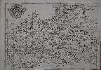
Imprint: London, 1 January 1777-[83]
Binding: Hardback Octavo (195 x 125 mm.), contemporary half calf, marbled paper boards, rebacked with raised bands, with gilt red calf title. With general plan, engraved title with contemporary ownership inscription cut upper right, pp. 7, (1), 44 and 44 maps, with contemporary manuscript pagination, front free endpaper working loose, otherwise in good condition.
Mostyn John Armstrong (fl.1769-91) was the son of Andrew Armstrong, both were cartographers although only the son published any atlas. Their focus was on Scottish related material with the notable exception of three large scale county maps of Cambridgeshire, Lincolnshire and Norfolk. The work was first published in 1776. This is the 'third edition' of this work, the date on the title page is altered to 1 January 1777. However in this example the dedication to Thomas Pennant on the following page is reset and now dated 23 August 1783 indicating a late issue. The ensuing preliminary leaves on Post Stages are reset with the inclusion of an N.B. referring to the late Act requiring 1d. per mile duty to be paid for each horse. The previous advert within the text for 'An Actual Survey of the Great Post-Road between London and Dover' is removed. The ‘Alphabetical Index of the Post-Towns’ is similarly reset. The plates themselves are consistently updated. Provenance: private English collection. References: Carroll (1996) App. 14.iii; ESTC N36298; Fordham (1924) p. 31 not differentiating the two 1776 editions.
Stock number:10189.
|
|
|
Imprint: London, 1st of August 1776
Binding: Hardback Octavo (190 x 120 mm.), contemporary half calf, marbled paper boards, spine with raised bands, blind ruled, with gilt red calf title, worn. With engraved title, pp. 7, (1), 44, (1), with general plan and 44 maps, in early outline colour, in good condition.
Mostyn John Armstrong (fl.1769-91) was the son of Andrew Armstrong, both were cartographers although only the son published any atlas. Their focus was on Scottish related material with the notable exception of three large scale county maps of Cambridgeshire, Lincolnshire and Norfolk. This is the second edition of this work, the date on the title page is altered to 1 August 1776, from 1 June, matching that of the dedication to Thomas Pennant on the following page. The title is expanded also with the insertion of �With the Country Three Miles, on each Side, Drawn on a Scale of Half an Inch to a Mile� to promote the scale of the depiction. The ensuing preliminary leaves are also altered somewhat being reduced from 8 to 7 pages. The advert for the map of Lincolnshire is replaced for an announcement of the availability of 'An Actual Survey of the Great Post-Road between London and Dover; With a general View of the Road to Paris' from December for 3s. The �Alphabetical Index of the Post-Towns� is reduced from two to one page, those towns within 3 miles of the route now deemed unnecessary to list.The plates themselves are also altered now bearing the names of the main towns and cities across the top. A further advert is placed at the back �For the Conveniency of Persons who wish to lighten the Expence of a Journey, and chuse at the same time their own Hours, Inns, Carriages, Company and Accommodations of every sort: there had been for some time established, A Traveller�s Office�, this being at �No. 2, Bridge-Street, opposite Ludgate-hill�. This example contains a small inserted map opposite plate number 24 of Durham. It is entitled 'Plan of the Roads from Scarbro' Whitby, & c. to Sunderland, Shields, & c. Through York, Durham, & c. and of that through Guisbro' Stockton, Castle Eden, & c.'. It records new turnpike roads opened in 1790 and 1797. Provenance: manuscript ownership inscription on the title of 'J. Clarke 1793', bookplate of William Gordon Ross, Royal Engineers, pasted on verso of the title; private English collection. References: Carroll App. 14.1; ESTC N16384; Fordham (1924) p. 31 not differentiating the two 1776 editions.
Stock number:9829.
|
|
|
Imprint: London, Printed for Robt. Sayer, Map & Printseller, No. 53, Fleet Street, 1787
Binding: Hardback Quarto (235 x 185 mm.), contemporary half calf, marbled paper boards, rebacked preserving the original red calf gilt title label, gilt compartments. With engraved title page, Index, pp. 4 and 30 engraved maps all in early wash colour, each with descriptive text, some light foxing, otherwise in good condition.
When John Bennett joined with Robert Sayer in partnership in 1774 it brought a new lease of life to the business. The plates from Thomas Jefferys ‘Small English Atlas’ were reissued with a short descriptive text. They recognised that the available county atlases of Scotland and Ireland were at least a generation old, those of Moll’s being first issued in 1725 and 1728 respectively. The Irish atlas appeared first using the talents of Bernard Scale in 1776. Hodson highlights the significance of the atlas ‘the rococo decoration characteristic of the work of Emanuel Bowen and Thomas Kitchin has disappeared from the maps: the new style, with its neo-classical influences, is simple and unadorned, almost austere.’For the Scottish atlas Sayer and Bennett brought in the talents of Mostyn John Armstrong (fl.1769-91). He was the son of Andrew Armstrong; both were cartographers although only the son published any atlas. Their focus was on Scottish related material with the notable exception of three large scale county maps of Cambridgeshire, Lincolnshire and Norfolk. As a young man Mostyn John Armstrong assisted his father Andrew Armstrong in the production of the large-scale map of Northumberland published in 1769. In 1775 he produced a map of Peeblesshire and in the following year the ‘Actual Survey of the Great Post Roads between London and Edinburgh’.The ‘Scotch Atlas’ contained 2 general maps, one of the environs of Edinburgh, and 27 maps of the counties. The plates were engraved by Harry Ashby in the new simpler style of the period as encompassed by John Cary. The maps are based on the landmark work of James Dorret published in 1750. In 1781 Bennett began to show signs of insanity and ‘in 1783 was admitted to Dr. Thomas Monro’s asylum in Clapton. In June 1784 Sayer brought a case to dissolve the partnership and Bennett’s name disappeared from the imprint after 1785’ (Worms & Baynton-Williams). This second edition ensued in 1787 with Sayer’s imprint alone. It was otherwise unchanged. One further edition was published in 1794 by Laurie and Whittle. Either of the first two editions are particularly scarce.This atlas once belonged to General Sir James Fergusson, K.G.C.B. (1787-1865), who served in the Peninsular Wars and was consistently promoted for action and bravery, ultimately becoming Major-General in 1841. He was made Governor of Gibraltar in 1855. Provenance: bookplate of General Sir James Fergusson inside front cover along with his inscription dated 1860 on first free endpaper; private English collection. Chubb 19; ESTC T194012; Moir (1973) I p. 94, 118-20 & II p. 153 no. 6A; Shirley (2004) T.Arm 3c; Worms & Baynton-Williams (2011).
Stock number:9814.
|
|
Imprint: London, Robert Sayer and Thomas Jefferys, 1768
Four uncut sheets each 490 x 630 mm., in early outline colour, with deckled edges in EXCELLENT CONDITION.
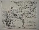
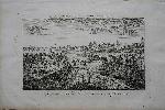
This is the first map of the county of Durham to be produced at a scale of one inch to the mile and the only one issued in the eighteenth century. It was surveyed by Lieutenant Andrew Armstrong and his son Mostyn John Armstrong; both were cartographers although only the son published any atlases. At the time Andrew Armstrong described himself as "Lieut. on half pay from the 32nd Regt." Their focus was on Scottish related material with the notable exception of the large scale county surveys of the neighbouring county of Northumberland which would be published the following year and two further of Lincolnshire in 1779 and Rutland in 1780. It was engraved and published by Thomas Jefferys. There are three states all published in rapid succession in the same year this being the third state with the imprint of both Robert Sayer and Thomas Jefferys. An Explanation upper right helps to identify the Market Towns, Parishes, Churches, Seats, Farms or Cottages, Parks, Turnpike Roads, 'Inclosed' partial and open roads and Roman points of interest. Also indicated are Coal Pits and Lead Mines along with natural features such as Hills, Woods and Parks etc. A fine plan of the town of Durham appears lower left accompanied by a compass rose and encapsulated by an ornate border. A nearby note records the fact that the latitude figures used were taken by Professor Hornsby in 1765. The longitude were deduced from the solar eclipse of 1766 and compared with those made at London, Sherborn and Oxford. The map is dedicated to Henry Earl of Darlington, the Lord Lieutenant of the county. The title appears in an ornate cartouche upper right with a mining scene. To its right is a model of the Bases and Triangles used to triangulate the county. All issues are rare, particularly this one. Provenance: private English collection. Harley, Brian �The Re-Mapping of England, 1750-1800� in Imago Mundi 19 pp. 56 & 63; Rodger (1972) 101; Worms & Baynton-Williams (2011).
Stock number:7216.
|
|
Imprint: London, 1843
630 x 515 mm., early outline colour, in good condition.
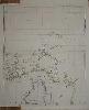
With a further inset entitled 'The Lower Course of the River Niger as far as it was ascended in the ...'. The voyage was known as the Niger expedition and was undertaken at the auspices of the British Government. It was undertaken by British missionary groups. It suffered from a high mortality due to disease. The island of St. Thomas is just shown at the bottom.
Stock number:7790.
|
|
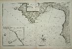
Imprint: London, 1745
235 x 355 mm., with folds as published in lower right margin extended after removal by binder, in good condition.
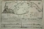
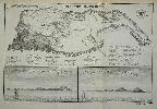
This plan of the island of Goree includes two views below of the Cape Verde Islands found just to the west. Goree is now known as Dakar in Senegal. From Thomas Astley, 'A Collection of Voyages and Travels' and engraved by Isaac Basire. Shirley BL G.Astl 1a no. 20.
Stock number:4860.
|
|
Imprint: London, 1745
240 x 360 mm., in fine condition.
The Island of Goree is a small island of just 45 acres (0.2 sq. km.) located only 2 km at sea from the main harbour of Dakar, Senegal. It was first occupied by the Portuguese c.1450 as a post to enable further southward exploration down the coast of Africa. In turn it became a Dutch, French and English possession. This plan of the island of Goree includes two views below of the Cape Verde Islands found just to the west. It is from the publisher Thomas Astley's "A New General Collection of Voyages and Travels" published in 1745. Archambault, 'The Map Collector' 45 pp. 28-30; Shirley Atlases in the BL G.Astl 1a no. 20.
Stock number:4485.
|
|
Imprint: London, E. Curll, 1718-[19]
255 x 360 mm., with folds as issued in good condition.
John Aubrey (1626-97) was as antiquary and natural philosopher. He is perhaps best known for his work 'Brief Lives', made up of a series of short biographical chapters. He was also an early archaeologist who recorded many monuments in England for the first time. He started studies on the natural history of Wiltshire and Surrey, neither were completed. Published posthumously in five volumes between 1718 and 1719 the work included this map. It is the first history of the county to be published. The map is dedicated to Sir John Fellowes. Upcott III p. 1207.
Stock number:9058.
|
|
|
Imprint: London, Printed for E. Curll in Fleet-Street, 1718-23
Octavo (195 x 120 mm.), five volumes, large paper copy, full contemporary tree calf, ornate gilt panelled, rebacked preserving the original ornate gilt spine with red calf gilt title labels affixed, marbled endpapers. Volumes dated 1719, 1719, 1718, 1718, 1723, with engraved portrait of the author, folding map of Surrey backed on linen, folding view of Richmond, folding table of John Evelyn's family tree, view of Albury and 8 further plates, in good condition.
THE FIRST COUNTY HISTORY OF SURREY in LARGE PAPER COPY. John Aubrey (1626-97) was as antiquary and natural philosopher. He is perhaps best known for his work Brief Lives, made up of a series of short biographical chapters. He was also an early archaeologist who recorded many monuments in England for the first time. He started studies on the natural history of Wiltshire and Surrey, neither were completed. Published posthumously in five volumes between 1718 and 1723, the work included a fine map of the county. The licence to survey the county, granted by John Ogilby, Royal Cosmographer, dated 1673 follows the title page. The map is dedicated to Sir John Fellowes. Provenance: Prof. R.C.G. Williams, OBE, his sale Clarke Gammon, Guildford, 14 November 2000 lot 190; private English collection. Anderson (1966) p. 268; Upcott (1968) III p. 1207.
Stock number:10343.
|
|
Imprint: Marseilles, 1746
Inscription: Signed, Inscribed Or Annotated 290 x 450 mm., in very good condition.
The "Recueil de Plusieurs Plans des Ports et Rades ... de la Mer Mediterranee" contained numerous plans of the Mediterranean ports and harbours. The plates are all signed "par iacques Ayrouard pilote real avec privilege du Roy grave par louis Corne". They show their engraver is one Louis Corne. The place of publication is unknown but presumed here to be Marseille, the home of a few similar works. The work is dedicated to Jean Frederick Phelypeaux Comte de Maurepas who was the Minister of the Navy to Louis XV. About Ayrouard surprisingly little is known other than his referral in the book to being a navigator with the French Royal Navy. This particular chart is of the bay and port of Palma, Majorca, in the Balearic Islands. NMM 206; Phillips 7862; Shirley Atlases in the BL M.Ayr 1a.
Stock number:4577.
|
|
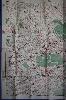
Imprint: London, Roadway Timetables, Bookings & Publications Ltd,, [1932]
1010 x 1265 mm., colour printed lithographic map with blue edged border all the way around, with original folds in very good condition.
An unusual Quad-Royal poster of the London Underground in that it is laid onto a map of Central London at the scale of just under 7 inches to the mile. A note in the upper margin states 'Southgate extension of the Piccadilly Railway from Finsbury Park is now under construction ...', this helps in dating it as the Southgate station opened on 13 March 1933. In 1933 the iconic Underground design by Harry Beck was first published. In this the lines of the Underground are colour coded and do not detract from the street plan itself. Red circles denote the stations which are reminiscent of the earlier design introduced in 1908. Stingemore style lines are shown in different colours.It extends from Willesden Green top left, Drayton Park and Holloway Road top right, Oval lower right, Hammersmith and Walham Green lower left and London Bridge and the Oval stations lower right. The imprints in the lower margin read from left to right 'Drawn by G.W. Bacon & Co., Ltd.', centre 'Copyright map by Roadway Timetables, Bookings & Publications Ltd, Roadway Corner, Warwick Street, London W.1.', and to the right 'Litho - J.Weiner Ltd, London W.C.1.' David Leboff and Tim Demuth, 'No need to ask! : Early maps of London's Underground Railways', p. 76 has a full page illustration of this map (lacking the blue border), with details on the opposite page.
Stock number:9018.
|
|
Imprint: London, 1742
Edition: First Edition Octavo (160 x 100 mm.), full recent calf, ribbed spine with gilt date and green calf gilt title label. With engraved title, Dedication, 5 tables, 4 general and 42 county maps, engraved throughout. Dedication with small tear repaired upper edge, some cleaning and regarding, otherwise in acceptable condition.
Thomas Badeslade (fl.1719-1745) was a surveyor and engineer who was involved in many schemes to improve the waterways. He was also an established author and in 1742 he had William Henry Toms engrave a series of maps from his draughts and publish them as the 'Chorographia Britanniae'. It is the first pocket size English county atlas published in the eighteenth century. It is surprising that it took so long considering the runaway success of the 'Britannia Depicta' of 1720. The first edition of the atlas is found in four variants and was on sale for only a short period of time. Within two or three months a new edition was published.The second issue placed plate numbers '8' and '9' on the two where it was omitted. This example is one of only three identified of the extremely rare third issue of the first edition of the 'Chorographia Britanniae'. Following the immediate addition of plate numbers to those of Cambridgeshire and Cheshire which had been omitted on publication Toms ordered the addition of the price to the end of the imprint on the title page. Even though all evidence shows the price of the atlas was 6 shillings from the start �Price Bound 5s� was added. The error was picked up immediately and corrected for the fourth and last variant of the first edition. Hodson could only find one example of this rare issue, that in the Royal Geographical Society (Ford 146). One other in a private collection is known to me and then this third example was uncovered. In the two privately held ones the price has been inked over to show 6s. Provenance: private English collection. Beresiner (1983) pp. 49-50; Chubb (1927) 170; ESTC T165385; Hodson (1984-97) no. 188 (atlas C p. 164); refer Shirley (2004) T.Bad 1a; Worms & Baynton-Williams (2011).
Stock number:9211.
|
|
|
Imprint: London, 1742
Binding: Hardback Octavo (165 x 105 mm.), half recent calf, blind ruled, marbled paper boards. With blind ruled raised bands, each compartment with blind and gilt ruling, gilt calf title attached. With engraved title, dedication, 3 tables, 4 general and 42 county maps and rates for Hackney carriages etc. engraved throughout. Middlesex and Oxford with lower centrefold split, otherwise a good example.
Thomas Badeslade (fl.1719-1745) was a surveyor and engineer who was involved in many schemes to improve the waterways. He was also an established author and in 1742 he had William Henry Toms engrave a series of maps from his draughts and publish them as the 'Chorographia Britanniae'. It is the first pocket size English county atlas published in the eighteenth century. It is surprising that it took so long considering the runaway success of the 'Britannia Depicta' of 1720. This is the identical to Hodson's atlas 'J' will all maps dated 1742 below. This is a late 1742 edition as it includes the two plates numbered 49 and 50 of the 'Rates of the Hackney Coaches'. Provenance: acquired in 2011 from Brian Kentish for a private English collection. Beresiner pp. 49-50; Hodson no. 189; Shirley BL T.Bad 1b.
Stock number:9777.
|
|
|
Imprint: London, c.1749
Edition: First Edition Binding: Hardback Oblong octavo (165 x 195 mm.), half early calf, marbled paper boards, blind ruled, rebacked with gilt ruled compartments, gilt date and gilt calf title label, early wove endpapers. With engraved title, dedication, 7 tables, 6 general and 40 county maps, engraved throughout and in fine full early wash colour. With the last line of the title page imprint shaved as often the case.
RARE OBLONG QUARTO EXAMPLE. Thomas Badeslade (fl.1719-1745) was a surveyor and engineer who was involved in many schemes to improve the waterways. He was also an established author and in 1742 he had William Henry Toms (fl.1723-61) engrave a series of maps from his draughts and publish them as the Chorographia Britanniae. It is the first pocket size English county atlas published in the eighteenth century. It is surprising that it took so long considering the runaway success of the Britannia Depicta of 1720. The first edition of the atlas is found in four variants and was on sale for only a short period of time. Within two or three months a new edition was published. This is an example of the final edition of the atlas. Usually the oblong quarto examples found are from the first issues. I cannot recall seeing a later edition clearly bound so. All of the plates were redated in the imprint to 1742, in that year. In 1745 Toms sold part of his copyright to Charles Hitch and for the edition of that year two new plates numbered 49 and 50 bearing details of the rates for Hackney coaches, chairmen and watermen. Around 1746 John Clark joined Hitch and Toms in owning the work but shortly after his share had come into the hands of William Johnston before December 1748 when Johnston placed an advert in the General Evening Post for it. Clark died in April 1746 and his business was continued by his wife Anne. It appears Johnston acquired the business premises of the Golden Ball as well as much of the stock from his widow. However not everything, she retained her interest in the London Magazine. The exact date of issue is not known. Hodson states that William Toms was still in Holborn in December 1748 and was at the present address by July 1750. By May of 1755 he had moved again. Hodson speculates therefore a date early in this period as Johnston would have been eager to get an edition published. Two similar atlases were being published at the time, the Geographia Magnae Britanniae by Thomas Osborne, 1748, and the Small English Atlas by Thomas Kitchin and Thomas Jefferys. Provenance: private English collection. Beresiner (1983) pp. 49-50; Chubb (1927) 174; ESTC N15269; Hodson (1984-97) no. 193 (atlas O p. 164); Shirley (2004) T.Bad 1e; Worms & Baynton-Williams (2011).
Stock number:10152.
|
|
|
Imprint: London, 1742
Edition: First Edition Binding: Hardback Octavo (165 x 100 mm.), full contemporary mottled calf, gilt ruled boards, rebacked with gilt ruled raised bands, calf gilt title label, original endpapers. With engraved title, Dedication, 5 tables, 6 general and 40 county maps, engraved throughout. In good condition.
FIRST EDITION, FIRST ISSUE. Thomas Badeslade (fl.1719-1745) was a surveyor and engineer who was involved in many schemes to improve the waterways. He was also an established author and in 1742 he had William Henry Toms (fl.1723-61) engrave a series of maps from his draughts and publish them as the 'Chorographia Britanniae'. It is the first pocket size English county atlas published in the eighteenth century. It is surprising that it took so long considering the runaway success of the 'Britannia Depicta' of 1720. The first edition of the atlas is found in four variants and was on sale for only a short period of time. Within two or three months a new edition was published.The second issue placed engraved plate numbers '8' and '9' to those of Cambridgeshire and Cheshire which had been omitted on publication. In this example they are added in manuscript. Following this Toms ordered the addition of the price to the end of the imprint on the title page. Even though all evidence shows the price of the atlas was 6 shillings from the start ‘Price Bound 5s’ was added. The error was picked up immediately and corrected for the fourth and last variant of the first edition. Provenance: with small ink stamp of a crown and 'SS' on first free endpaper; private English collection. Beresiner (1983) pp. 49-50; Chubb (1927) 170; ESTC T165385; Hodson (1984-97) no. 188 (atlas A p. 164); refer Shirley (2004) T.Bad 1a; Worms & Baynton-Williams (2011).
Stock number:10149.
|
|
|
Imprint: London, 1742
Edition: First Edition Binding: Hardback Oblong octavo (240 x 265 mm.), full recent calf by Temple Bindery, gilt ruled boards, gilt ruled ribbed spine with dark blue gilt title label, later endpapers. With engraved title, Dedication, 5 tables, 6 general and 40 county maps, engraved throughout and in full early wash colour. Kent re-guarded and with lower right corner small repair, otherwise in very good condition.
FIRST EDITION, SECOND ISSUE IN MAGNIFICENT EARLY WASH COLOUR. Thomas Badeslade (fl.1719-1745) was a surveyor and engineer who was involved in many schemes to improve the waterways. He was also an established author and in 1742 he had William Henry Toms (fl.1723-61) engrave a series of maps from his draughts and publish them as the 'Chorographia Britanniae'. It is the first pocket size English county atlas published in the eighteenth century. It is surprising that it took so long considering the runaway success of the 'Britannia Depicta' of 1720. The first edition of the atlas is found in four variants and was on sale for only a short period of time. Within two or three months a new edition was published.The second issue placed engraved plate numbers '8' and '9' to those of Cambridgeshire and Cheshire which had been omitted on publication. Provenance: retaining the early bookplate of William Bell, Ulcomb, Kent, a William Bell was Rector of the church at Ulcomb from 1740; private English collection. Beresiner (1983) pp. 49-50; Chubb (1927) 170; ESTC T165385; Hodson (1984-97) no. 188 (atlas A p. 164); Shirley (2004) T.Bad 1a; Worms & Baynton-Williams (2011).
Stock number:10150.
|
|
Imprint: Liverpool, 1824-5
Binding: Hardback Quarto (280 x 205 mm.), contemporary half calf, paper boards bearing original ornate title, gilt ruled and titled spine. With 12 maps of which 4 are folding and 8 town plans, plus 2 folding tables. Light wear but otherwise in good condition.
This collection contains a fine large folding map of the county by W. Wales with attractive vignette of Liverpool. A similar sized plan of Liverpool by Neele & Son. The two tables of the distances of the principal towns of England and the 'Population Returns of England' drawn from the 1821 census. Single sheet town plans of Preston, Lancaster, Ashton under Lime, Stockport, Bolton, Blackburn, Rochdale and Oldham, a large folding of Manchester, general map of England and Wales. Provenance: Bow Windows Bookshop.
Stock number:7293.
|
|
|
Imprint: London, 1802
Binding: Hardback Octavo (225 x 140 mm.), old half vellum, contemporary paper boards, later endpapers, uncut. With typographic frontispiece, pp. iv, 66, with 14 aquatint plates of the roads with early wash coloured borders and 5 further aquatints, in good condition.
James Baker (fl.1791-1806) is first noted from 'A Picturesque Guide to the Local Beauties of Wales and the Marches', 1791-94. This beautifully engraved aquatint road book was like many, published in parts. Its unusual feature is that the roads are represented by a series of vignettes of the views found along the route. It has a complicated bibliography which is not fully understood. This is not helped by the fact that each example appears to include differing content. Volume I, published in four parts, was completed in 1802. Despite intending further parts, no record of any exists. Five of the plates in this example are variously dated between 1800 and 1801, the balance bear no dates. There are recorded examples in which some of the earlier plates are dated between December 1798 and March 1799. The first part appears to have been issued in 1799. After a delay, there appears to have been a rush to finish the ensuing three parts to complete the first volume. It would also appear that as publication drew close, by the end of 1802, Baker had the plates with dates from the previous century updated. Smith and Webb describe the poor organisational skills of Baker supported by the number of examples of the atlas which vary in content. An unusual very rare road book. Provenance: Dominic Winter auction 15 December 2010 lot 63; private English collection. Refer Abbey Scenery (1952) 8 & 514; Fordham (1924) p. 46; Smith & Webb (1988) ‘James Baker’s Picturesque Plans’ in The Map Collector no. 42 pp. 20-26; Worms & Baynton-Williams (2011).
Stock number:10218.
|
|
Imprint: London, c.1790
180 x 265 mm., in good condition.
This fine copper plate engraving of the city of Dublin is from Thomas Bankes' 'New and Complete System of Geography'.
Stock number:7636.
|
|
Imprint: Rome, 1763
390 x 530 mm., light foxmark on the upper edge in the margin, printed on thick paper in good condition.
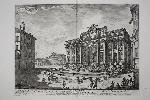
This fabulous view of the Trevi Fountain in Rome is found in Jean Barbault's 'Les Plus Beaux Edifices de Rome Moderne'. Olschki states that the views of Barbault occupy an honourable place in the iconography of Rome. Various street sellers are set up in the foreground. I very recognisable image. Barbault studied in Paris before settling in Rome. He entered Rome at the time Piranesi was active and worked with him as well as becomming a rival. Barbault contributed figures to fourteen plates by Piranesi in volumes 2 and 3 of the 'Antichita Romane', 1754. There were not many collaborators. Seven years later Barbault's own collection of views on ancient Rome was published. In both this and the posthumously published 'Les Plus Beaux Edifices de Rome Moderne' (1763) from which this plate is drawn, Barbault drew on several views from Piranesi's earlier work. In the views of "modern" Rome, Barbault is, inevitably, close to Piranesi's contemporary views. Berlin Cat. 2712; Brunet I 546; Fowler 37; Olschki 16397.
Stock number:8624.
|
|