|
|
|
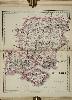
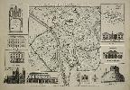
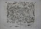
Imprint: London, G. & J. Cary, 86 St. James's Street, 1832
Binding: Hardback Oblong folio (565 x 690 mm.), contemporary half calf, green cloth boards, gilt ruled, gilt title embossed on upper board, ornate gilt raised bands, gilt ruled compartments, gilt title, marbled endpapers, front one with small tear, light wear. With engraved title, general key map, map of England and Wales in 65 numbered sheets, all in early outline colour, some offsetting otherwise in fine condition.
This work follows on the Cary tradition of a large-scale map of England and Wales dissected and published in atlas form. John Cary would first publish one as a wall map in 1792 followed 2 years later by the 'New Map of England and Wales, with part of Scotland' in atlas form with 81 sheets in 1794. It was replaced by newly engraved plates for a 'second edition' 1816. This was published and corrected through to 1834. The origin of this map goes back to 1819 with an extensive advert in 'Cary's New Itinerary' of 1819 which stated, 'Part the First, containing the whole of Cornwall & part of Devonshire, will be published early in the ensuing autumn'. The advert in the 1821 edition stated 'Parts I & II are now published ...'. By 1828 ten parts had been published. The intention was to issue the map in fourteen parts priced at £1 1s. each, in 63 sheets. On completion it consisted of 65 sheets.As it was issued the dates varied accordingly but when the whole was published here in 1832 the imprints were brought up to date. As is often the case, the whole would not make up a rectangular map. Those portions which would have covered empty sea have been omitted.' It is very fully and clearly engraved, giving great detail' (Fordham). Provenance: private English collection. Fordham (1925) pp. 120-1; Smith (1988); Worms & Baynton-Williams (2011).
Stock number:10215.
|
|
|
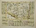
Imprint: London, 20 June 1800
Edition: First Edition Small quarto (180 x 120 mm.), full contemporary calf, rebacked with double gilt ruled compartments, gilt date and calf gilt title label, light wear. With engraved title page, facing Explanation, folding general map, 50 full page maps, all in early outline colour with some wash to woods and parks, Index to place-names in three columns pp. 13., in good condition.
John Cary (c.1754-1835) and descendants were possibly the most prolific publishers of cartography around the turn of the nineteenth century. Cary is noted for the clarity of detail in his maps and was the first to use the Greenwich meridian. He had already published road books; his first publication is one showing the roads between London and Falmouth, 1784. For this work the large scale of one inch to the mile allowed John Cary to include a great deal of detail including local side roads. As the title describes 'every seat thereon, with the name of the Possessor ... to which is added, An Index of all the Names contained in the Plates'. Each individual building is detailed. The small format allowed a broader sale as it fitted nicely into the pocket. A very useful tool even for researchers today. Twenty eight of the fifty plates were first published on 1 January 1786 as Cary's Actual Survey of Middlesex. The first edition of this expanded work with 50 plates is dated 20 June 1786. This is the second updated edition of 1800. Those few plates which bore 1786 dates have here been altered to 15 August 1800. Effort has been made to correct ownership details of the properties illustrated. The book is still available at the same price 'Price 8s. sewed' as shown on the title page, however the address is altered from 188 Strand to 181 Strand, London. He moved to this address in 1791. The only other alteration is to the Index which is entirely reset now in three columns per page and now in only 13 pages. One further edition was issued in 1811. Provenance: unidentified bookplate with motto 'Prodesse' pasted inside front cover; private English collection. Beresiner (1983) pp. 80-2; Darlington & Howgego (1964) 183.1; ESTC N26951; Fordham (1925a) pp. 22-3; Worms & Baynton-Williams (2011).
Stock number:10193.
|
|
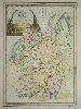
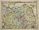
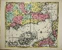
Imprint: London, 1875
Quarto (235 x 155 mm.), full modern calf, spine with double gilt ruled compartments, black calf gilt title label, marbled endpapers. With title page, Index of maps, general map of England and Wales, 43 county maps on 44 plates (West Riding being on two plates) and both North and South Wales, 47 maps in total, all in early wash colour.
George Frederick Cruchley (1797-1880) had learned his trade with Aaron Arrowsmith and began to work for himself in 1823. His early days were concentrated on publishing maps of London but following the death of John Cary in 1834 he acquired much of the stock from the surviving heirs. Cruchley made lithographic transfers from the plates until he sold them all in 1877. Cruchley�s main marketing tool was to add to the original plates details of the railways, postal, telegraph and other useful information. These plates were originally published by Cary as the 'New and Correct English Atlas', 1809. Although quite probably acquired at an earlier date Cruchley does not appear to have made use of them until 1863 when he published the 'County Atlas of England & Wales'. There were further dated editions of 1864 and 1875 with undated issues in-between. This is an example of the last dated edition of George Cruchley�s 'County Atlas of England & Wales'. All editions are rare. Provenance: David Kingsley collection August 1989; private English collection. Beresiner pp. 93-5; Chubb 555; Nicholson (2003) �G. F. Cruchley and �Maps for the Million�, in IMCoS Journal 93 pp. 21-38; Smith, �George Frederick Cruchley, 1796-1880�, in 'The Map Collector' no. 49 pp. 16-22.
Stock number:9662.
|
|
|
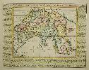
Imprint: London, G. F. Cruchley, Map Seller & Globe Maker, 81, Fleet Street, London, 1875
Binding: Hardback Quarto (240 x 155 mm.), full contemporary cloth boards, ornate blind panelled boards with gilt embossed title to upper board, spine with blind ruled compartments, front free endpaper torn away. With title page, Index of maps, general map of England and Wales, 43 county maps on 44 plates (West Riding being on two plates) and both North and South Wales, 47 maps in total, all in early wash colour, the general and final maps with small centrefold split, otherwise in good condition.
George Frederick Cruchley (1797-1880) had learned his trade with Aaron Arrowsmith and began to work for himself in 1823. His early days were concentrated on publishing maps of London but following the death of John Cary in 1835, he acquired much of the stock from the surviving heirs. Cruchley made lithographic transfers from the plates until he sold them all in 1877. Cruchley’s main marketing tool was to add to the original plates, details of the railways, postal, telegraph and other useful information. These plates were originally published by Cary as the 'New and Correct English Atlas', 1809. Although quite probably acquired at an earlier date, Cruchley does not appear to have made use of them until 1863 when he published the 'County Atlas of England & Wales'. There were further editions of c.1864 and 1875. This is an example of the last dated edition of George Cruchley’s 'County Atlas of England & Wales'. All editions are rare. Provenance: original booksellers label of T. W. Arthur, Carlisle, affixed inside upper cover; private English collection. Beresiner (1983) pp. 93-5; Chubb (1927) 555; Nicholson (2003) ‘G. F. Cruchley and ‘Maps for the Million’, in 'IMCoS Journal' 93 pp. 21-38; Smith (1989b) ‘George Frederick Cruchley, 1796-1880’, in 'The Map Collector' no. 49 pp. 16-22.
Stock number:10230.
|
|
Imprint: London, 1821
465 x 1015 mm., in full early wash colour, two sheets joined, in good condition.
This map was published in John Cary's 'New Universal Atlas' first published in 1808. John Cary (c.1754-1835) was one of the most successful map and globe publishers of the late eighteenth and early nineteenth centuries. Cary was the first map maker to use Greenwich as the meridian. The clarity of his style sets him apart from the competition. This is a later edition with the date in the imprint altered to 1821. Phillips 714 no. 37-8.
Stock number:9203.
|
|
Imprint: Rome, 1795
480 x 350 mm., recent wash colour, in good condition.
This map was published in Cassini's very rare three volume 'Nuovo Atlante Geografico Universale' 1792-1801 published in Rome by the Calcografia Camerale and appeared in the first volume dated 1792. Cassini (1745-c.1824) was a painter and engraver in Rome, this arguably being his finest publication. Phillips Atlases 670.
Stock number:4626.
|
|
Imprint: Paris, Charpentier rue S. Jacques au Coq, c.1740
345 x 520 mm., in good condition.
Etienne Charpentier (1707-92) was an engraver, publisher and print seller who established himself in 1736. He bagan by taking over the stock of the widow of Jean-Baptiste-Henri Bonnart. This is a fine engraving of the Chateau at Meudon
Stock number:8896.
|
|
Imprint: London, John Rocque, 1750
450 x 690 mm., in very good condition printed on excellent thick paper.
One of the best large and detailed copper plate engraved plans of York, published by John Rocque in 1750 from a survey by Peter Chassereau. Chassereau was one of many members of French Huguenot society who settled in London. He became a surveyor and cartographer in Soho operating at �the Sign of the Golden Head, Berwick St.� One of his earliest works was a plan of the town and harbour of Havana for Thomas Bowles in 1739. One of the last works attributed to him is this plan of York for his fellow French Huguenot John Rocque.The city of York is depicted in great detail showing in the southern extreme the �Distillery� on the west bank of the River Ouse and the Dyke leading to the Castle on the east side. The whole of the old town is displayed with the old walls and gates identified. Of great interest are the several fields still shown within the old walls. The map is surrounded by 10 inset views and one map upper right. The map shows the whole �County of Yokr� misspelt with all the Roman roads. Notable structures in town occupy the other insets including the title upper left within an ecclesiastical architectural structure, the County Hospital, the City House, the west prospect of the Cathedral, a section of the Assembly Room, the Thursday Market and Pavement Crosses, the Prison, the Assembly Rooms and Cliffords Tower. Rocque�s imprint appears outside the neat line at the bottom of the plate. Jean Rocque (c.1704-62), to use his native name, was a Huguenot �migr� who at an early age settled in England. By 1734 he was a surveyor, engraver and publisher. His work is renowned for its beauty as well as its accuracy and several important large scale maps were produced by him. Amongst his several productions are only four large scale county maps, the first was of Shropshire in 1752 followed by Middlesex, 1757, Berkshire 1761 and Surrey posthumously in c.1768. He was most prolific in producing several large-scale maps of towns and estates. This is a fine example of the first state of the map by John Rocque; a second state was published by his widow in 1766. For a detailed biography of John Rocque and a list of his works, see Map Forum Issue 3 online. Provenance: auction 2010; private English collection. Barron (1988); Butler (1989); Map Forum Issue 5, �The Works of John Rocque� no. 57.
Stock number:9299.
|
|
Imprint: Amsterdam, c.1710
Binding: Hardback 145 x 260 mm., on a folio sheet with two further views either side. In fine condition.
From the encyclopaedic seven volume 'Atlas Historique' by HenriChatelain. Shirley 'Atlases in the BL' T.Chat-1a; Koeman II p. 33.
Stock number:4310.
|
|
Imprint: Amsterdam, 1708
345 x 450 mm., full wash colour, in good condition.
This plate illustrates the ecclesiastical civil and military structure of Knights of Malta, the Teutonic Order, structures with ancient lineage. It was published in the second volume of the encyclopaedic atlas by Henri Abraham Chatelain (1684-1743) entitled 'Atlas Historique ou Nouvelle Introduction a l'Histoire, a la Chronologie & a la Geographie'. It was issued from 1705 to 1720 in 7 volumes. Koeman II p. 33; Phillips 579; Shirley 'Atlases in the BL' T.Chat-1a; Van Waning 'Chatelain's Atlas Historique' in IMCoS Journal 120 pp. 7-15.
Stock number:8978.
|
|
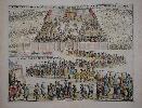
Imprint: Amsterdam, 1708
360 x 455 mm., full wash colour, small tear in upper margin not affecting the image otherwise in good condition.
The ONLY KNOWN ILLUSTRATION OF THE RIDING OPENING THE SCOTTISH PARLIAMENT. Before the Union of 1707 the annual opening of the Scottish Parliament was occasioned a famous procession from Holyrood House to Parliament House. Here all of the dignitaries are shown leaving Holyrood lower left and making their way to Parliament top centre. Each individual or group is identified and the inside of the Parliament is illustrated. It was published in the second volume of the encyclopaedic atlas by Henri Abraham Chatelain (1684-1743) entitled 'Atlas Historique ou Nouvelle Introduction a l'Histoire, a la Chronologie & a la Geographie'. It was issued from 1705 to 1720 in 7 volumes. Koeman II p. 33; Phillips 579; Shirley 'Atlases in the BL' T.Chat-1a; Van Waning 'Chatelain's Atlas Historique' in IMCoS Journal 120 pp. 7-15.
Stock number:8982.
|
|
Imprint: Amsterdam, c.1715
360 x 460 mm., in recent wash colour and good condition.
An attractive map of the Balkans region of south east Europe centred on the River Danube. It is surrounded by descriptive text in French. It was published in the second volume of the encyclopaedic atlas by Henri Abraham Chatelain (1684-1743) entitled 'Atlas Historique ou Nouvelle Introduction a l'Histoire, a la Chronologie & a la Geographie'. It was issued from 1705 to 1720 in 7 volumes. Koeman II p. 33; Phillips 579; Shirley 'Atlases in the BL' T.Chat-1a; Van Waning 'Chatelain's Atlas Historique' in IMCoS Journal 120 pp. 7-15.
Stock number:9347.
|
|
Imprint: Amsterdam, c.1715
380 x 435 mm., in recent wash colour and good condition.
A very attractive map of Madagascar with very ornate panels surrounding illustrating the people and their customs. In the centre is descriptive text in French. It was published in the sixth volume of the encyclopaedic atlas by Henri Abraham Chatelain (1684-1743) entitled 'Atlas Historique ou Nouvelle Introduction a l'Histoire, a la Chronologie & a la Geographie'. It was issued from 1705 to 1720 in 7 volumes. Koeman II p. 33; Phillips 579; Shirley 'Atlases in the BL' T.Chat-1a; Van Waning 'Chatelain's Atlas Historique' in IMCoS Journal 120 pp. 7-15.
Stock number:9348.
|
|
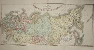
Imprint: Amsterdam, c.1715
410 x 510 mm., in fine modern wash colour, good condition.
A strongly engraved map of Russia, from the Caspian Sea to Korea, filled with minute detail and beautifully engraved to show the topography. With an Inset of explanatory French text at upper right. It was published in the encyclopaedic seven volume 'Atlas Historique'. Koeman II p. 33; Shirley 'Atlases in the BL' T.Chat-1a; Van Waning 'Chatelain's Atlas Historique' in IMCoS Journal 120 pp. 7-15.
Stock number:9406.
|
|
Imprint: Amsterdam, c.1719
380 x 485 mm., in recent full wash colour, good condition.
This map of Asia with surrounding descriptive text was published in the encyclopaedic seven volume 'Atlas Historique' by Henri Abraham Chatelain (1684-1743). Koeman II p. 33; Shirley 'Atlases in the BL' T.Chat-1a; Van Waning 'Chatelain's Atlas Historique' in IMCoS Journal 120 pp. 7-15.
Stock number:9410.
|
|
Imprint: Amsterdam, c.1715
385 x 430 mm., in fine recent wash colour, in good condition.
A detailed plate on the ecclesiastical situation in Greece. It is topped with a central map of Greece and surrounded by four corner images of religious costumes. Across the middle is descriptive text. It was published in the fifth volume of the encyclopaedic atlas by Henri Abraham Chatelain (1684-1743) entitled 'Atlas Historique ou Nouvelle Introduction a l'Histoire, a la Chronologie & a la Geographie'. It was issued from 1705 to 1720 in 7 volumes. Koeman II p. 33; Phillips 579; Shirley 'Atlases in the BL' T.Chat-1a; Van Waning 'Chatelain's Atlas Historique' in IMCoS Journal 120 pp. 7-15.
Stock number:9110.
|
|
Imprint: Amsterdam, c.1715
345 x 450 mm., in full recent wash colour, in good condition.
The centre of the plate bears two views of Moscow, above these is an image of the Czar bestowing medals on his people. It is surrounded with descriptions of the noble families in Russia. It was published in the fourth volume of the encyclopaedic atlas by Henri Abraham Chatelain (1684-1743) entitled 'Atlas Historique ou Nouvelle Introduction a l'Histoire, a la Chronologie & a la Geographie'. It was issued from 1705 to 1720 in 7 volumes. Koeman II p. 33; Phillips 579; Shirley 'Atlases in the BL' T.Chat-1a; Van Waning 'Chatelain's Atlas Historique' in IMCoS Journal 120 pp. 7-15.
Stock number:9479.
|
|
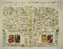
Imprint: Amsterdam, c.1719
380 x 465 mm., in recent full wash colour, good condition.
This chart displays the family tree of the House of Stuart whose English reign begins with James I and extends through Charles I and II and James II. It was published in the second volume of the encyclopaedic atlas by Henri Abraham Chatelain (1684-1743) entitled 'Atlas Historique ou Nouvelle Introduction a l'Histoire, a la Chronologie & a la Geographie'. It was issued from 1705 to 1720 in 7 volumes. Koeman II p. 33; Phillips 579; Shirley 'Atlases in the BL' T.Chat-1a; Van Waning 'Chatelain's Atlas Historique' in IMCoS Journal 120 pp. 7-15.
Stock number:9719.
|
|
|
Imprint: Amsterdam, 1708
625 x 515 mm., folding as issued, full wash colour, in good condition.
A magnificent display of the family tree of the House of Austria including 20 coats of arms. It includes the nobility of Spain, Portugal, France, Italy, Germany and Austria. Several tables identify the Arms which are keyed using letters running all the way around the outside of the image. It was published in the second volume of the encyclopaedic atlas by Henri Abraham Chatelain (1684-1743) entitled 'Atlas Historique ou Nouvelle Introduction a l'Histoire, a la Chronologie & a la Geographie'. It was issued from 1705 to 1720 in 7 volumes. Koeman II p. 33; Phillips 579; Shirley 'Atlases in the BL' T.Chat-1a; Van Waning 'Chatelain's Atlas Historique' in IMCoS Journal 120 pp. 7-15.
Stock number:9757.
|
|
|
Imprint: Amsterdam, c.1719
405 x 965 mm., two sheets joined as one, in recent full wash colour, good condition.
This fine large two sheet decorative plate features the House of Valois. The large family tree bears four vignette views below of the Place Royale, Tuilleries and Palais du Luxembourg in Paris. It was published in the final seventh volume of the encyclopaedic atlas by Henri Abraham Chatelain (1684-1743) entitled 'Atlas Historique ou Nouvelle Introduction a l'Histoire, a la Chronologie & a la Geographie'. It was issued from 1705 to 1720 in 7 volumes. Koeman II p. 33; Phillips 579; Shirley 'Atlases in the BL' T.Chat-1a; Van Waning 'Chatelain's Atlas Historique' in IMCoS Journal 120 pp. 7-15.
Stock number:9713.
|
|