|
|
Imprint: London, Henry Geoge Collins, 22, Paternoster Row, c.1848
Inscription: Signed, Inscribed Or Annotated Octavo (190 x 125 mm.), full contemporary publishers calf, with original closing flap and remainder of silk tie, with very ornate gilt title embossed on upper board. With engraved title page containing vignette, Contents leaf, and 45 maps consisting of a large folding general map of England and Wales, North Wales, South Wales and 42 maps of the English Counties (Yorkshire consisting of the three Ridings), all in full wash colour
Henry Teesdale (fl.1828-45) a successful publisher in London is best known for two English County atlases. In 1829 he acquired the county plates to Robert Rowes exceedingly rare English Atlas and after revision published them as the New British Atlas. Encouraged by its undoubted success he embarked on a reduced sized county atlas which he published the following year entitled A New Travelling Atlas. In this work the roads are made the principal feature. For some reason it was not a great success, at least judging from the fact that only two examples survive: Cambridge University Library and a private English collection. For the second edition in 1843, plate numbers were added, as were railways in the counties where they had been introduced. Again only a handful of examples survive. Both series of copper plates became the property of Henry George Collins (fl.1832-58) and the 'Travelling Atlas' was re-issued with his imprint in 1849. For this edition the maps were lithographic transfers which enabled greater use from the plates without wear. The familiar 'piano keyboard' borders are replaced by a three line one. Further railways are added. Provenance: manuscript ownership marks of 'Jno Wilkinson 1857' inscribed inside front cover; private English collection. Carroll (1996) no. 92.A; refer Chubb (1927) no. 529; Worms & Baynton-Williams (2011).
Stock number:9333.
|
|
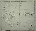
Imprint: Paris, 1775
455 x 520 mm., small foxmark in lower margin away from the image, upper right side margin cut close to facilitate binding, replaced, with folds as issued in the book, in good condition on thick paper.
This find large scale sea chart of the southern tip of South America and the Falkland Islands comes from the French edition of Captain James Cook's voyage around the world entitled 'Voyage dans l'Hemisphere Australe et autour du Monde'. An inset lower right focuses on New Years Island and nearby harbour on Staten Island at the tip of Tierra del Fuego. The whole is engraved by Benard. Sabin 16249.
Stock number:5118.
|
|
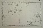
Imprint: Paris, c.1785
210 x 330 mm., in good condition.
This chart describes the Friendly Islands as discovered by Captain James Cook which appear in the French edition of his travels entitled 'Voyage dans l'Hemisphere Australe et autour du Monde'. The whole is engraved by Benard. Sabin 16249.
Stock number:5760.
|
|
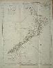
Imprint: Paris, Saillant et Nyon & Panckouke, 1774
480 x 380 mm., with old folds as issued in the volume, with a pin sized hole as might be expected to double fold, strong watermark, in excellent condition.
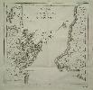
The voyages of Abel Tasman in 1642 discovered the west coast of the South Island of New Zealand but he identified the land as an extension of that found by Willem Cornelisz Schouten and Jacob Le Maire and named is Staten Land. It was not until Captain James Cook arrived at the eastern shore of the North Island on 6 October 1768 and sailed around the islands that their true identity was revealed. Land was first sighted by a boy called Nicholas Young and his immortality continues in the naming of Young Nicks Head to this day. Immediately Cook set about mapping the islands, including observing on the 9 November the transit of Mercury which enabled them to fix the location of a point north of the Coromandel Peninsula. Poor weather hampered some of the charting but he did fix the northern tip of the island to within two minutes of its actual latitude and four minutes in longitude. After repairs Cook continued mapping the South Island and by the end of March had completed his task and proved the insular nature of New Zealand.The official account of Cooks First Voyage was published in London in 1773 and includes this, the FIRST MAP OF NEW ZEALAND. This example comes from the French translation appearing the following year and is engraved by Robert Bénard. Suarez (2004) pp. 130-1; Tooley, R. V. Map Collector Series no. 64, no. 339; Tooley, R.V. (1979) pl. 21.
Stock number:6287.
|
|
Imprint: Paris, Saillant et Nyon & Panckouke, 1774
270 x 275 mm., old folds as issued in the book, some minor spotting, otherwise in very good condition.
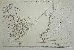
A fine chart of Cook Strait in New Zealand, the site of present day Wellington can be found lower right. Cook Strait was actually first noted by Abel Tasman in 1642 who thought that it was a bight closed off at the eastern end. He named it Zeehaens Bight. It was Captain James Cook who proved it was in fact a Strait. Tooley, R. V. Map Collector Series 64, no. 341.
Stock number:6288.
|
|
Imprint: London, 1784
225 x 335 mm., lower left corner trimmed not affecting the image otherwise in good condition.
From G.W. Anderson, 'New Authentic and Complete Collection of Voyages Round the World ...' Anderson's voyages was first published in weekly parts, the work described the voyages of Cook along with many other English eighteenth century ones. Shirley 'Atlases in the British Library' G.And 1a no. 11.
Stock number:5758.
|
|
|
Imprint: Amsterdam, 1778
245 x 460 mm., with vertical folds as issued, in good condition.
A fine engraving of Tongataboo from the Dutch edition of the voyages of Captain Cook, 1778.
Stock number:9447.
|
|
|
Imprint: Paris, 1778
230 x 460 mm., with vertical folds as issued, in good condition.
A fine engraving by Robert Bernard published in the French edition of the voyages of Captain Cook, 1778. Shirley G.Cook 3a.
Stock number:9443.
|
|
|
Imprint: Paris, 1778
230 x 460 mm., with vertical folds as issued, in good condition.
A fine engraving by Robert Bernard published in the French edition of the voyages of Captain Cook, 1778. Shirley G.Cook 3a.
Stock number:9444.
|
|
|
Imprint: Paris, 1778
230 x 460 mm., with vertical folds as issued, in good condition.
A fine engraving by Robert Bernard published in the French edition of the voyages of Captain Cook, 1778. Shirley G.Cook 3a.
Stock number:9445.
|
|
|
Imprint: Paris, 1778
230 x 375 mm., with vertical folds as issued, in good condition.
A fine engraving by Robert Bernard published in the French edition of the voyages of Captain Cook, 1778. Shirley G.Cook 3a.
Stock number:9446.
|
|
|
Imprint: Amsterdam, 1778
245 x 460 mm., with vertical folds as issued, in good condition.
A fine engraving of New Hebrides from the Dutch edition of the voyages of Captain Cook, 1778.
Stock number:9448.
|
|
|
Imprint: Amsterdam, 1778
245 x 450 mm., with vertical folds as issued, in good condition.
A fine engraving of New Hebrides from the Dutch edition of the voyages of Captain Cook, 1778.
Stock number:9449.
|
|
|
Imprint: Amsterdam, 1778
245 x 450 mm., with vertical folds as issued, in good condition.
A fine engraving of New Hebrides from the Dutch edition of the voyages of Captain Cook, 1778.
Stock number:9450.
|
|
|
Imprint: Paris, 1778
230 x 360 mm., in wash colour, with vertical folds as issued, in good condition.
A fine engraving by Robert Bernard published in the French edition of the voyages of Captain Cook, 1778. It illustrates the world famous monuments on Easter Island. Shirley G.Cook 3a.
Stock number:9442.
|
|
|
Imprint: London, 1773
210 x 400 mm., with vertical folds as issued, in good condition.
A fine engraving from the voyages of Captain Cook, 1773.
Stock number:9453.
|
|
Imprint: Paris, Saillant et Nyon & Panckouke, 1774
275 x 430 mm., old folds as issued in the book, in very good condition.
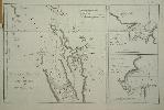
Please see the earlier Cook entry for further information. The present day Auckland is found on the left side of the left half of the map. There are two further charts to the right. Tooley, R. V. Map Collector Series no. 340.
Stock number:6289.
|
|
|
Imprint: London, 1774
240 x 470 mm., with vertical folds as issued, in good condition.
A fine engraving from the voyages of Captain Cook, 1774.
Stock number:9451.
|
|
|
Imprint: Paris, 1778
230 x 360 mm., with vertical folds as issued, in good condition.
A fine engraving by Robert Bernard published in the French edition of the voyages of Captain Cook, 1785. It displays a native boat of the Marquises Islands. Shirley G.Cook 3a.
Stock number:8618.
|
|
Imprint: London, Thomas Bowles, John Bowles and Robert Sayer, 1735-[c.65]
550 x 700 mm., early outline colour, cut, dissected and laid on linen as issued. A couple of light marks and two small worm tracks at the edge lower right, otherwise in good condition.
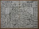
James Corbridge was a surveyor in Norwich in the first half of the eighteenth century. He produced numerous estate plans but is best known for his large scale maps of Norfolk, Norwich and Great Yarmouth. His career began in Newcastle and amongst his early work is the first plan of the town. In the early 1720s he moved to Norwich and in 1730 he published his great large scale map of the county of Norfolk, the first to be printed. In 1735 he published this large single sheet reduction complete with extensive lists of the towns and villages in the county in surrounding panels. Each is keyed to the map and has their Hundred identified along with the distance in miles from Norwich. Circles of distance from Kings Lynn and Norwich radiate the map. The coastline is decorated with ornate images of seven boats and ships. Top centre can be found Corbridges dedication to Baron Walpole. The map is engraved to the scale of three miles to the inch, each grid marking three miles. The year after the publication of the larger map Thomas Goddard and William Chase published a pirated copy. In this reduction by Corbridge he could not resist having a go at them about the scale of miles stating lower right I refer them to Mr. Chase and his Map (if they doubt my Scale of Miles which contains 1760 yards) for if I mistake not he has given three Scales to his Map which he calls Great Middle and Small, things Uncommon in Surveys of Countys and as useless as the 3 heads Imployd in Copying My Late Map of Norfolk. Thomas and John Bowles and Robert Sayer were the publishers of the second edition of the Norwich town plan and the original map of Norfolk. The map is NOT LISTED IN RODGERS list of large scale maps and only one example appears to have ever appeared at auction. According to Raymond Frostick this is the second of four known states. Frostick, James Corbridge, IMCoS Journal no. 115 pp. 33-40; Frostick Norfolk 27.2; not in Rodger.
Stock number:7416.
|
|