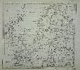
Item details: A Chart of the Baltic Sea, Gulfs of Finland and Bothnia, with the Sound, Drawn from the Best Maps & Charts by T. Jefferys, Geographer to His Royal Highness the Prince of Wales
£ 175.00
JEFFERYS, Thomas
A Chart of the Baltic Sea, Gulfs of Finland and Bothnia, with the Sound, Drawn from the Best Maps & Charts by T. Jefferys, Geographer to His Royal Highness the Prince of Wales
Imprint: London, 1748
240 x 260 mm., in good condition.
This attractively engraved map of the Baltic Sea by Thomas Jefferys was published in the March 1748 issue of the Gentleman's Magazine. A legend gives the details of the Treaty of Abo of the 16 June 1743 between Sweden and Russia. Jolly, D.C. (Brit Per) GENT-55.