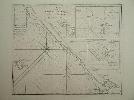
Item details: Chart of the West Coast of Sumatra from Bencoolen to Keysers Bay
£ 175.00
LAURIE, Robert - WHITTLE, James
Chart of the West Coast of Sumatra from Bencoolen to Keysers Bay
Imprint: London, Laurie & Whittle, 1786-[94]
640 x 930 mm., in good condition with very wide margins. Some light offset.
This chart is found in examples of Laurie and Whittle's "Complete East India Pilot". It shows the extreme south western shore of Sumatra leading to the Straits of Sunda. Inset plans of Cawoor Bay, Pulo Pisang and Little Fortune Island with Billimbing Bay are all by Captain Joseph Huddart. Joseph Huddart (1741-1816) was a Captain in the East India Company as a hydrographer and civil engineer. This chart was one of many of his work which are found in Laurie and Whittle's "Complete East India Pilot" which was first published in 1798. NMM 379 no. 146.