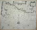
Item details: De Custen van Bretaigne, Waer in vertoont wort alle gelegentheyt tuschen Caap de Hague en t'Eylant Heyssant
£ 1150.00
GOOS, Pieter
De Custen van Bretaigne, Waer in vertoont wort alle gelegentheyt tuschen Caap de Hague en t'Eylant Heyssant
Imprint: Amsterdam, c.1650
430 x 530 mm., centre fold split, excellent restored. Fine condition, dark impression, with decent margins all the way around.
A very fine sea chart of the coasts of Brittany with dark engraving by Pieter Goos. Orientated with south at the top it displays prominently the Channel Islands. The French coastline from the Cherbourg Peninsula to Brest is also depicted. These treacherous waters are amply illustrated with anchorages, reefs and harbours. Englands Portland Bill is in the lower left. This chart lacks any imprint and as other Dutch sea charts of the period are very similar identifying it can be problematic. By comparing images of known maps I have I can rule out it being by Jansson or Lootsman. This leaves Pieter Goos or Theunisz Jacobsz. Jacobsz published the Lichtende Columne, ofte Zee-Spiegel in 1644; Goos published his version in 1652. The collations of both first editions in Koeman give the charts pagination 37; our chart is numbered 38. Koeman records that for the 1669 English edition the pagination was altered to 38 and the assumption is therefore that this is our example. The main area of difference on the map between the versions appears to be the nomenclature of Portland Bill. Koeman (1967-70) Goos 17 no. 43 & Goos 35 see note at the end.