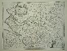
Item details: The Countie Palatine of Chester Comitatus Cestrensis
£ 850.00
JANSSON, Jan
The Countie Palatine of Chester Comitatus Cestrensis
Imprint: Amsterdam, 1636
385 x 505 mm., a tear to the lower margin with an extremely professional repair, not effecting the image, in good condition. With German text to the verso.
By the 1630s the publication houses of Willem Blaeu and Henricus Hondius were in a race to produce ever more new maps of the world. Hondius in partnership with Jan Jansson began collecting plates of Britain and in 1636 published an Appendix of the Atlas including 17 maps, two of which were general ones. Unfortunately they were not ready in time for the English edition published in 1636 and are only found in the German edition. This marks the beginning of the race between the two houses to produce a separate volume devoted to England and Wales which Blaeu would win in 1645. In 1644 a further 11 maps were issued in a Dutch Appendix. Examples of maps from these early issues are very rare and highly desirable. The plates are often extensively altered for their ultimate issue in the completed work of 1646.A very rare example of the FIRST STATE of Jan Janssons map of the county of Cheshire. One of the fifteen so called pre-issue maps published in 1636 before the final work was completed in 1646. The most notable feature of this early state of Cheshire is the decorative title cartouche upper left, in the finished state it is moved lower left and replaced by seven coats of arms. Not so noticeable is that the imprint of Jan Jansson lower right below the scale of miles is erased and replaced with a whole new cartouche for the scale only. Janssons name is left out altogether. Koeman (1967-70) II ME 44 no. 414; Van der Krogt (1997-2003) 5375:1.1; Map Collectors Circle Notes and Addenda pp. 16-18; Skelton (1970) pp. 225-6.