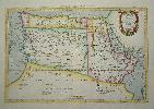
Item details: Tab. IV. Africae, in qua Libya Interior et Exterior. Aethiopia sub Aegypto et Interior ...
£ 450.00
MERCATOR, Gerard - PTOLEMY, Claudius
Tab. IV. Africae, in qua Libya Interior et Exterior. Aethiopia sub Aegypto et Interior ...
Imprint: Utrecht, Francois Halma, 1578-[c.1695]
310 x 470 mm., in fine modern wash colour and in good condition.
From Gerard Mercator's edition of 'Claudii Ptolemaei Tabulae Geographicae Orbis Terrarum'. It was in 1578 that one of the world's greatest cartographers put out an edition of the earliest surviving geographical treatise. This map shows the northern half of Africa with the equator displayed prominently. The source of the Nile River is also highlighted with a mountain range feeding two large lakes. An interesting feature is the Niger River in 'Libya' which is prominent across the map with its source in numerous lakes. During its course to the sea it disappears under a mountain range arising the other side. Although Mercator is most renowned today for the projection he popularised and for first using the term 'atlas' for a collection of maps, he devoted much of his life to his Ptolemaic maps. The maps were beautifully engraved as nearly as possible to their original form and are the most decorative of Ptolemaic maps. Koeman Me 5; Nordenskiold 234; Phillips, P.L. (Atlases) 384; Shirley BL T.Ptol-11a & 11k; Van der Krogt, P. (Atlantes) 1:501.