Item details: A New Chart for Sailing Between the Straits of Sunda or Batavia and the Straits of Banca and Gaspar
£ 325.00
LAURIE, Robert - WHITTLE, James
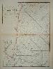
A New Chart for Sailing Between the Straits of Sunda or Batavia and the Straits of Banca and Gaspar
Imprint: London, 1787
660 x 485 mm., in fine modern outline colour with light browning along the centre fold, otherwise fine.
A fine detailed chart of the waters around Batavia, or present day Jakarta in Indonesia. Jakarta can be seen lower right with the historically important port of Bantam further to the west. The Straits of Sunda are featured before the coast of Sumatra. A fascinating detail is the presence of Cracatoa in the Straits which was famously destroyed when it erupted in 1883. This chart is found in examples of Laurie and Whittle's 'Complete East India Pilot'. NMM 379 no. 154.