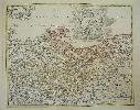
Item details: Tabula Marchionatus Brandenburgici et Ducatus Pomeraniae quae sunt Pars Septentrionalis Circuli Saxoniae Superioris ...
£ 250.00
HOMANN, Johann Baptist
Tabula Marchionatus Brandenburgici et Ducatus Pomeraniae quae sunt Pars Septentrionalis Circuli Saxoniae Superioris ...
Imprint: Nuremberg, c.1720
420 x 540 mm., early wash colour with light colour offset in one area, otherwise in good condition.
A large scale map of the region to the east of Hamburg, Germany. The map extends to Lubeck and upriver to Hitzger. With an inset of Hadeln. The famous German firm of cartographic publishers was founded by the engraver Johann Baptist Homann in 1702 in Nuremberg. In 1707 he published the "Neuer Atlas" whose success continued for many years. In recognition of his success Homann was elected to the Berlin Academy of Sciences. In 1715 Homann was appointed Geographer to the Emperor. Homann died in 1724 and the business was continued by his son Christoph (1703-30) and his heirs. Shirley, R.W. (BL Atlases) T.HOM-8a, Vol. V, #1.