 |
£ 5500.00
|
KITCHIN, Thomas - JEFFERYS, Thomas
The Small English Atlas, being A New and Accurate Sett of Maps of All the Counties in England and Wales
Imprint: London, 1751
Edition: 1
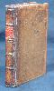
Small quarto (160 x 115 mm.), full contemporary calf, gilt embossed panels, with gilt bands to spine along with red calf gilt title label. Engraved throughout, pictorial title, one leaf containing preface and index, 50 engraved maps, ALL IN EARLY OUTLINE COLOUR with yellow wash borders, Rutland with tear in the map repaired, otherwise a good example.
This small and attractive atlas was first published November 1748 in thirteen weekly parts by a consortium of nine publishers. No copy of this version survives and it seems likely that Jefferys and Kitchin took over the project at an early date. At some point before the publication of the second edition in 1751 alterations were made to some of the plates. During the issue of this 1751 edition plate numbers were added therefore the states of the maps can vary. This example of the 1751 edition bears 4 maps still in their first state, 26 in their second state and 20 in the third state. The atlas proved popular, running to 6 editions, with various changes and additions, the last being in 1787. Provenance: Manuscript ownership inscription of George Evelyn March 15 1756; Powderham Castle, Library of the Earl of Devon. Chubb (1927) no. 193; Hodson (1984-97) no. 210; refer Shirley (2004) T.Kit 2a (not in BL).
Stock number:5245.
|