Item details: Tab. I. Europae, Continens Albion, Britanniam, et Hiberniam ...
£ 375.00
MERCATOR, Gerard - PTOLEMY, Claudius
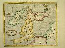
Tab. I. Europae, Continens Albion, Britanniam, et Hiberniam ...
Imprint: Amsterdam, R & J Wetstenii & G Smith, 1578-[1730]
340 x 400 mm., recent wash colour, in good condition.
Gerard Mercator's edition of Ptolemy's 'Geography' is highly acclaimed, he spent much of his life studying the work and even engraved the plates himself. The 'Geographia' is the earliest surviving geographical treatise. Much of Mercator's efforts were spent projecting Ptolemy's geography onto the projection which bears his name. Mercator is one of the worlds greatest cartographers and the 'Claudii Ptolemaei Tabulae Geographicae Orbis Terrarum' was first published in 1578. This map of the British Isles is in the third state with the addition of a latitude and longitude grid illustrating the projection. Koeman Me 5; Nordenskiold 234; Phillips, P.L. (Atlases) 384; Shirley BI 123; Shirley BL T.Ptol-11a & 11k; Van der Krogt, P. (Atlantes) 0901:1.2.