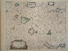
Item details: Caarte voor en Gedeelte der Canarise Eylanden als Canaria, Tenerifa, Forteventura, etc.
£ 895.00
GOOS, Pieter
Caarte voor en Gedeelte der Canarise Eylanden als Canaria, Tenerifa, Forteventura, etc.
Imprint: Amsterdam, 1666 Edition:
First Edition
430 x 530 mm., early outline colour, even light toning not offensive, in good condition.
This is a rare and desirable sea chart of the Canary Islands. It shows La Palma, Gomera, Tenerife, Gran Canaria, Forteventura and Lanzarote. An inset upper right features the harbour of Lanzerote. It was published in the first edition of Pieter Goos Zee-Atlas, a highly influential and regarded work. Koeman (1967-70) IV Goos IB no. 22; Phillips (1909-) 5690-22.