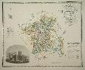
570 x 780 mm., early wash colour, with centrefold split repaired, otherwise in good condition.
Following the extensive work carried out by the Greenwood's on the series of large scale county surveys a reduced sized atlas was planned. It began as early as 1829, the date recorded on 11 of the plates. It was advertised in 1828 to appear in four parts at three guineas per part. There were to be 46 plates all at one-third of an inch to a mile. Running into financial difficulties towards the end they had to take in partners to finally finish in 1834. 'For detail, general accuracy and balance allied to high quality engraving and colouring these sheets are probably the finest ever single sheet maps of the counties' (Carroll). This map of Worcestershire contains a fine vignette view of Worcester Cathedral. Tooley's 'Dictionary of Mapmakers', Chubb 458B.