Item details: Insula S. Juan de Puerto Rico Caribes, vel Canibalum Insulae
$US 1950.00
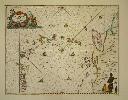
JANSSON, Jan
Insula S. Juan de Puerto Rico Caribes, vel Canibalum Insulae
Imprint: Amsterdam, 1650
400 x 510 mm., in early outline colour with some GOLD to the central compass rose, in good condition.
This attractive sea chart is oriented to the east, the central compass rose pointing to the north is highlighted in GOLD. It displays the Leeward and Windward islands stretching between Puerto Rico and South America. All of the islands are named, and the whole is beautifully ornate with lovely colour. The decorative title cartouche includes Neptune and cherubs. Lower right the map is embellished with a native holding the scale of miles. A superb chart first published in Johannes Janssonius' 'Atlantis Majoris' the first sea atlas of the world only pre-dated by the much more cumbersome six-volume 'Arcano del Mare' by Sir Robert Dudley in 1646-7. With no text on the verso as issued. Koeman 652; Van der Krogt, P. (Atlantes) 9640:1.