Item details: Tabula Transeundi Maris Orientalis, Septentrionalis, et Occidentalis
£ 450.00
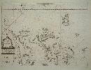
MERIAN, Matthaus
Tabula Transeundi Maris Orientalis, Septentrionalis, et Occidentalis
Imprint: Frankfurt, 1644
260 x 360 mm., in very good condition.
This rare sea chart of western Europe is from Johann Angel von Werdenhagen's 'De Rebus Publicis Hanseaticis' published in 1644. Although unsigned the map is the work of the engraver Matthaus Merian. It is derived from Willem Blaeu's similar chart from his sea atlas. The orientation is to the west and it extends from Tenerife to Spitsbergen. Phillips 7645; Shirley 'Atlases in the BL' G.Werd 1a no. 133.