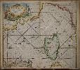
Item details: Nieuwe Paskaert van de Zee Kusten van Provence en Italiae ... de Zee Kusten van t'Eylandt Corsica ...
£ 3250.00
KEULEN, Gerard van
Nieuwe Paskaert van de Zee Kusten van Provence en Italiae ... de Zee Kusten van t'Eylandt Corsica ...
Imprint: Amsterdam, c.1710
515 x 590 mm., in good outline colour, in good condition.
The firm of Van Keulen was founded around 1678 by Johannes van Keulen (1654-1715) and in 1680 he published the 'Zee Atlas'. The multi volume 'Zee Fakkel' followed soon after. On his 50th birthday he left the management of the firm to his talented son Gerard (1678-1726). Gerard set about replacing many of his fathers sea charts the first of which was published in 1698. This fine chart is of the Ligurian Sea and extends from the coast of Sardinia in the south to Italy and the island of Elba. The coastline extends westward to the Provencal port of Toulon in France. Dominating the map is the island of Corsica. The whole is finished with two ornate cartouche. This example is from the third part of 'De Nieuwe Groote Lichtende Zee-Fakkel' dated 1724 which covered the Mediterranean Sea. De Vries, Schilder etc. 'The Van Keulen Cartography Amsterdam 1680-1885', pp. 44 & 202-5; Koeman IV p. 381 no. 105 st. 2; Koeman 'The Sea on Paper' p. 37-8 no. 7.