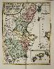
Item details: Les Royaumes de Valence et Murcie tirez de Cantel ... Los Reynos de Valencia y de Murcia ...
£ 650.00
NOLIN, Jean Baptiste
Les Royaumes de Valence et Murcie tirez de Cantel ... Los Reynos de Valencia y de Murcia ...
Imprint: Paris, c.1707
565 x 435 mm., in fine recent wash colour, with fold as issued, in very good condition.
A very fine rare map of the regions of Valencia and Murcia in south eastern Spain first published at an unknown date. The scale of the map is quite wonderful extending from Cartagena in the south to Tortosa in the north. To the right of the map is much of the island of Ibiza. The whole of the Balearic Islands are illustrated in an inset lower right entitled 'Royaume et Isles de Maillorque'. A cartouche upper left bears the title written in French and Spanish and dedicated to the King of Spain Felipe V who reigned from 1700-24. Jean Baptiste Nolin (1657-1708) was a geographer, engraver and publisher on the Rue St. Jacques in Paris. This example was most likely bound into 'Le Theatre du Monde', his atlas first published in 1707. Shirley 'Atlases in the British Library' T.NOL 2a II no. 21.