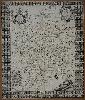
Item details: To the most Honble: ... This Map of Staffordshire ...
£ 2250.00
PLOT, Robert
To the most Honble: ... This Map of Staffordshire ...
Imprint: Oxford, 1682-[86]
640 x 540 mm., trimmed close, with folds as issued, in good condition.
FIRST STATE. Robert Plot (1640-96) was the first keeper of the Ashmolean Museum in Oxford and official historiographer to James II. Following the success of Plot's first published work, the 'Natural History of Oxford', published in Oxford in 1677 he issued a work on Staffordshire. It has been described as being better written than that of Oxfordshire. Both were accompanied by large and extremely attractive maps of the counties. This map of Staffordshire is by Gregory King (1648-1712), engraved by Joseph Browne (fl.1678-82) and dated 1682. King (1648-1712) from Lichfield was a surveyor, draughtsman and engraver who went to London in 1672. There through the great engraver Wenceslaus Hollar he met John Ogilby and helped produce many of the road strips for his 'Britannia' in 1675. It is known from his autobiography that he had worked on a map of the county early on. It is an extremely ornate map decorated by numerous coats of arms of the subscribers. This is a good example of the FIRST STATE of five known, a very fine dark engraving. Provenance: private English collection. King (1988) pp. 25 & 66-8; Tooley Dictionary; Worms & Baynton-Williams (2011).