Item details: Descripcion de las Yndias del Norte 2
$US 1800.00
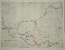
HERRERA Y TORDESILLAS, Antonio de
Descripcion de las Yndias del Norte 2
Imprint: Madrid, 1601
215 x 280 mm., in good condition.
In 1601 Antonio de Herrera y Tordesillas published the first four parts of his Historia General. It is usually bound in two volumes; at the end of the second is often found the Descripción de las Indias Occidentalis containing fourteen maps of Spanish possessions, largely in America ... Herrera was the official historian of Castile and the Indies to Philip II of Spain. Considering the dearth of Spanish publications on the New World, particularly cartographic, it is noteworthy that this book had official backing. It details the early exploration of the New World by the Spanish and assembles many documents lost to us today. The geography of the maps is largely derived from the manuscript charts of Juan López de Velasco, c.1575-80. At least four of these have survived; one resides in the John Carter Brown Library, Rhode Island. On this map the most noticeable feature used is the distinctive narrow Florida peninsula. The lack of any great detail still reflects the official policy of protecting Spanish knowledge of the New World; despite this the outline of the maps is accurate. The only name to appear in North America is la florida (Burden). A rare item. Borba de Moraes (1958) vol. 1, p. 336; John Carter Brown Library Annual Report, 1944-45 pp. 12 & 24-5; Burden (1996-2007) 141; Martin & Martin (1984) p. 77; Wagner (1937) pp. 66-7; Wagner (1924) no. 12; World Encompassed (1952) no. 231; Wroth (1944) pp. 158-9, no. 55 and pl. XII (López de Velasco charts).