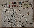
Item details: An Accurate Map of the County of Huntingdon, Actually Survey'd after a New method, in the Years 1730 & 1731
£ 150.00
GORDON, William
An Accurate Map of the County of Huntingdon, Actually Survey'd after a New method, in the Years 1730 & 1731
Imprint: London, 1731
495 x 595 mm., in early outline colour, with a couple of small holes along the centrefold all professionally restored, otherwise in good condition.
This is one sheet only from the first large scale map of the county of Huntingdon. The only other issued in the eighteenth century was by Thomas Jefferys in 1768. Gordon's map in 6 sheets is one of only a dozen produced in the eighteenth century on the very large scale of 2 inches to the mile. Indeed it is one of the very first multi-sheet map of any English county ever published. Engraved by Emanuel Bowen this sheet includes the title with Bowen's imprint beneath. It depicts the region south of Peterborough displayed beneath the coats of arms. It includes Woodstone, Atanground, Fletton, Overton Longville, Farcet, Yaxley and Whittlesey. Rodgers 196.