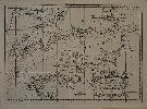
Item details: A Chart of the English Channel with the adjacent Coasts of England and France
£ 60.00
KITCHIN, Thomas
A Chart of the English Channel with the adjacent Coasts of England and France
Imprint: London, October 1758
185 x 260 mm., with folds as issued, in good condition.
From the 'London Magazine'. Folded as issued. Right hand margin slim. Thomas Kitchin was one of the most notable English cartographers of the eighteenth century. He was both an engraver and publisher of considerable reputation who was made Hydrographer to King George III. He worked with many of his contemporaries on various projects. His first notable work was the maps for the 'London Magazine' from 1747 to 1760. Jolly, D.C. (Brit Per) Lond-149.