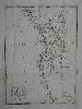
Item details: Charte von Nieder-Guinea nach den besten vorhandenen Hulfsmitteln . . . 1811
£ 125.00
EHRMANN, Theophil F
Charte von Nieder-Guinea nach den besten vorhandenen Hulfsmitteln . . . 1811
Imprint: Prague, 1806-[11]
415 x 305 mm., early outline colour, with folds as issued in very good condition.
This map of the south west coast of Africa extends from the equator south to 25 degrees and takes in Equatorial Guinea and Gabon to Namibia. The map is centred on Angola and the Congo. and was first published by the Weimar Geographische Institut in Vienna 1806. This state comes from the two volume "Neuste kunde von Afrika" published in Prague, 1811, by Diesbach. Tooley's Dictionary.