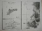
Item details: Plan of Easter Island Taken in April 1786 [on sheet with] Plan of Cook's Bay
£ 175.00
LA PEROUSE, Jean Francois Comte de
Plan of Easter Island Taken in April 1786 [on sheet with] Plan of Cook's Bay
Imprint: London, G. G. & J. Robinson, 1799
380 x 500 mm., in good condition.
This is a map representing the visit of the French Admiral and explorer, le Comte de La Pérouse to Easter Island in 1786 in the Pacific Ocean. In three panels, with a view. From the London firm of Robinson's highly rated English translation of the original French edition of the 'Atlas du Voyage de La Perouse' published in 1797. Hill p. 174; Suarez, T. (Pacific) p.169, fig.164.