Item details: A New Chart of the Archipelago Corrected by Ion. Gaudy
£ 425.00
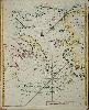
GAUDY, John
A New Chart of the Archipelago Corrected by Ion. Gaudy
Imprint: London, W & J Mount and T. Page at the Postern on Tower Hill, 1716-[47]
535 x 440 mm., in fine recent outline colour, in good condition.
This fine rare sea chart of the Aegean Sea was first published in Mount & Page's 'English Pilot Part Three' in 1716. Engraved by Samuel Parker this example is from the 1747 edition. Dotted or 'Prickt Lines shows The best Passage up the Arches'. The 'Arches' were the colloquial name for the Archipelago. There is a fascinating depiction of Sentorim (Santorini) with a nearby 'Burning I' showing an erupting volcano. NMM 425 no. 146; Shirley 'Atlases in the BL' M.M&P 3b no. 24; Sphyroeras, Avramea and Asdrahas 'Maps and Map-Makers of the Aegean' fig. 127 (incorrectly attributing the map to Seller); Zacharakis 2162.