Item details: A Chart of the Levant or the Sea Coast of Egypt Syria Caramania and the Island Cyprus newly Corrected by Iohn Gaudy
£ 875.00
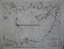
GAUDY, John
A Chart of the Levant or the Sea Coast of Egypt Syria Caramania and the Island Cyprus newly Corrected by Iohn Gaudy
Imprint: London, W & J Mount and T. Page at the Postern on Tower Hill, 1716-[47]
400 x 530 mm., minor restoration to lower margin and corners, otherwise in good condition.
A sea chart of the eastern Mediterranean Sea featuring Cyprus by John Gaudy and engraved by Samuel Parker. It extends westward to include part of the island of Crete. The nearby island of Rhodes is also displayed and it extends into the Aegean Sea as far as Patmos. It was published in Mount & Page's 'English Pilot First Part' covering the Southern Navigation and was included from at least 1716. Shirley, R.W. (BL Atlases) M.M&P-3b no. 29; Zacharakis, C. 2159.