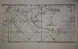
Item details: Carte de l'Entree de la Tamise avec les Bancs, Passes, Isles et Costes Comprise entre Sandwich et Clay
£ 650.00
JAILLOT, Alexis Hubert
Carte de l'Entree de la Tamise avec les Bancs, Passes, Isles et Costes Comprise entre Sandwich et Clay
Imprint: Paris, 1693 Edition:
First Edition
460 x 900 mm., in fine condition, with very large margins, thick paper and superb watermark, a nice dark impression.
Alexis Hubert Jaillot (1628-88) was the leading French cartographer of the late seventeenth century. The Neptune Francois was first published in Paris in 1693. Issued with official approval it was a magnificent work with beautifully engraved large clear plates. It was however immediately copied by Pierre Mortier who issued an edition in Amsterdam before the year was finished. With superior Dutch marketing the Dutch editions were a success. The Paris edition suffered accordingly and is today quite rare. This detailed chart from the FIRST EDITION and therefore in the FIRST STATE covers the waters from the Isle of Thanet in Kent to the Norfolk Broads taking in Essex, and Suffolk on the way. Pastoureau (1984) Neptune Francais A no. 8; Shirley (2004) T. M.Nep 1a.