Item details: A New Map of Surrey From The Latest Authorities
£ 95.00
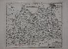
LODGE, John
A New Map of Surrey From The Latest Authorities
Imprint: London, 1790-[c.95]
265 x 330 mm., small margin tear upper right not affecting the image, repaired, otherwise in good condition.
This map of the county of Surrey was one of a series first published in 'The Political Magazine' between 1782 and 1790, all carried the name of the engraver, John Lodge (fl.1755-96). First appearing in 1780 the 'Political Magazine' was published by John Bew. However from October 1789 it was in the hands of Robert Butters. It is the imprint of Butters which appeared below the map along with the published date of 30 June 1790. The magazine's last issue was in December 1791 and ensuing ownership of the plates in not known. It was issued undated in the 'Atlas of Great Britain and Ireland' c.1795 by an unknown publisher. Both works are extremely rare. Chubb 250; Jolly I POL 145; Worms & Baynton-Williams (2011).