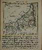
130 x 135 mm., in early outline colour with text below, in good condition.
A small and attractive map of Cornwall, it was first published in an atlas issued in thirteen weekly parts by a consortium of nine publishers, commencing in November 1748. No copy of this version survives, and it seems likely that Jefferys and Kitchin took over the project at an early date. At some point before the publication of the second edition in 1751 alterations were made to some of the plates as seen here. During the issue of the 1751 edition plate numbers were added therefore contents can vary in the states of the maps. This is an example before the addition of plate numbers. The atlas proved popular, running to six editions, with various changes and additions, the last being in 1787. Chubb 193; Hodson 210; Quixley (1966) 31; refer Shirley BL T.Kit 2a (not in BL).