 |
£ 950.00
|
JOHNSON, Thomas
Johnson’s Atlas of England; With all the Railways Containing Forty Two Separate Maps of the Counties and Islands
Imprint: Manchester, Thos. Johnson, 1847
Binding:
Hardback
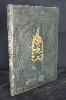
Quarto (280 x 215 mm.), full contemporary green cloth binding, blind tooled panels with ornate blind corner decoration, gilt vignette and title to upper board, gilt title to spine dated 1849, light wear. With title page, contents leaf and 42 full fresh early wash coloured maps, each interleaved, last half dozen leaves with water damage to upper edge, otherwise in good condition.
The plates for this VERY RARE atlas are by Joshua Archer (1792?-1863) and were first published in William Pinnocks Guide to Knowledge, 1833. Archer was declared bankrupt shortly after in 1835 and was in prison for debt again in 1845. What is unusual about the plates for this period is that they were produced using woodblocks and printed directly resulting in a map which is white on black. The process of lithographic transfer was used for Thomas Johnsons atlas offered here. This preserves the original block or plate from excessive wear and allows an extended life. A Thomas Johnson is recorded as being a bookseller, stationer, bookbinder, printer and publisher in Liverpool between 1833-43. This is possibly the same Johnson as our publisher after a move to Manchester. For this atlas, the existence of some of the early railways is recorded. One further edition appeared in 1863 surviving in just two known examples. Provenance: manuscript annotation on front endpaper 'Stephen James Adams 1850'; private English collection. Carroll (1996) no. 98; Chubb (1927) no. 523; Worms & Baynton-Williams (2011).
Stock number:9247.
|