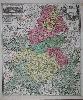
580 x 490 mm., full early wash colour in good condition.
A wonderful detailed map of the Champagne district in France. The map extends are far north as Compiegne and Neuchatel and south to Auxerre. An inset upper left illustrates the two towns of Troyes and Reims. The map is by Johann Baptist Homann (1664-1724) who began engraving and publishing separate maps around 1702, and producing standardised and composite atlases entitled 'Neuer Atlas' in 1707. Its success continued for many years and in recognition of his success Homann was elected to the Berlin Academy of Sciences. In 1715 Homann was appointed Geographer to the Emperor. This map includes the privelege granted to Homann Shirley believed in 1715. Heinz, Markus (1997). A Programme for Map Publishing: The Homann Firm in the Eighteenth Century, Imago Mundi, no. 49, pp. 104-15; Shirley (BL Atlases) T.HOM-1c, no.16.