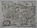
Item details: Provinciae Cantii Vulgo Kendt Nova Descriptio
£ 395.00
JANSSON, Jan
Provinciae Cantii Vulgo Kendt Nova Descriptio
Imprint: Amsterdam, 1644
380 x 500 mm., small hole in the upper right margin, lower centre fold split, repaired, not affecting the image, otherwise in good condition.
By the 1630s the publication houses of Willem Blaeu and Henricus Hondius were in a race to produce ever more new maps of the world. Hondius in partnership with Jan Jansson began collecting plates of Britain and in 1636 published an 'Appendix' of the Atlas including 17 maps, two of which were general ones. Unfortunately they were not ready in time for the English edition published in 1636 and are only found in the German edition. This marks the beginning of the race between the two houses to produce a separate volume devoted to England and Wales which Blaeu would win in 1645. In 1644 a further 11 maps were issued in a Dutch 'Appendix'. Examples of maps from these early issues are very rare and highly desirable. The plates are often extensively altered for their ultimate issue in the completed work, the 'Atlas Novus' of 1646.An example of the very rare FIRST STATE of Jan Janssons county map of Kent. When compared to the rival Blaeu county maps those of Jansson always appear more decorative. This map of Kent, with German text to the verso taken from Camden's 'Britannia', was first published in 1644. All so-called pre-issue Jansson county maps are rare and desirable. A comparison of the two states shows that the extremely ornate title cartouche was entirely re-engraved along with numerous other alterations. Jansson was a very successful publisher who continued the business first founded by the great Gerard Mercator and subsequently taken over by the Hondius family. Burgess 15 state 1; Koeman (1967-70) II ME 75A no. 559; Van der Krogt (1997-2003) 5290:1.1; Map Collectors Circle 34 'Notes and Addenda' pp. 16-18; Skelton (1970) no. 34, pp. 225-6.