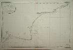
Item details: Carte de la cote meridionale d'Angleterre depuis Douvres jusqu'a Winchelsea.
£ 150.00
JOHNSTONE, Capt. - TAPPER, M
Carte de la cote meridionale d'Angleterre depuis Douvres jusqu'a Winchelsea.
Imprint: Paris, 1822
625 x 950 mm. Very slight offsetting upper right.
This detailed chart of the Kent coastline was surveyed by Capt. Johnstone and M. Tapper according to the title. It extends from Dover westwards to Winchelsea, Sussex.The Depot des Cartes et Plans de la Marine was the government hydrographic service of France. It was founded in 1720 to provide the French Navy with accurate charts and was headed first by Jacques Nicolas Bellin. Tooleys Dictionary.