Imprint: London, Andrew Dury and William Herbert, 1768
485 x 600 mm., with original folds still in very good condition.
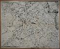
This detailed plan of Canterbury by John Andrews and Matthew Wren is separately published by Andrew Dury and William Herbert, but is more usually found with Andrews and Dury's twenty-five sheet large scale map of the county of Kent published a year later in 1769. At the bottom outside the neatline is an advertisement for the large scale map announcing that it will shortly be published on a scale of two inches to the mile. This plan is drawn to the large scale of about 175 feet to the inch. John Andrews (fl.1766-98) was a geographer, surveyor, engraver and mapseller in London who is particularly well known for his fine collaborations with Andrew Dury. Matthew Wren had already worked with Andrews on plans of Hertford and St. Albans. The finished product was published jointly by Andrews and William Herbert. Worms & Baynton-Williams (2011).