Item details: Cary's Survey of the High Roads from London to Hampton Court, Bagshot ...
£ 995.00
CARY, John
Cary's Survey of the High Roads from London to Hampton Court, Bagshot ...
Imprint: London, July 1st., 1790 Edition:
First Edition
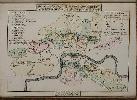
Quarto (215 x 155 mm.), full contemporary calf, ornate gilt spine with red calf gilt title. With engraved title page, folding general map, foxed, map of the Turnpike Gates, both in early wash colour, Explanation and Advertisement, and 80 strip road maps on 40 double-page sheets all in early wash colour. Engraved throughout, with minor offsetting. Complete with original endpapers.
FIRST EDITION. John Cary (c.1754-1835) and descendants were possibly the most prolific publishers of cartography around the turn of the nineteenth century. Cary is noted for the clarity of detail in his maps and was the first to use the Greenwich meridian. In 1794 he was commissioned by the Postmaster-General to survey the roads of Great Britain. Cary had already published road books; indeed his first publication is one showing the roads between London and Falmouth, 1784. In 1790 Cary published his Survey of the High Roads from London which contained twelve routes from the town and eighteen cross roads. All are in lovely early colour and display a wealth of information. It was particularly pointed out by Cary that the country houses along the route could be seen from certain vantage points which are marked out on the maps. It was reissued unaltered in 1799, in 1801 and again in 1810. There were no further editions. An example of the FIRST EDITION. Beresiner (1983) pp. 80-2; Fordham (1925) pp. 40-1; Fordham (1924) p. 40; Shirley (2004) T.Cary 4a.