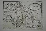
230 x 315 mm., in early wash colour and good condition.
An attractive map of the island of Hindoustan or northern India from Jacques Nicolas Bellin's greatest atlas, the 'Petit Atlas Maritime'. This copperplate engraved map shows the whole northern India with detail naming towns, cities and rivers. The rococo-style title cartouche bears a distance scale. Phillips 638 & 3508; Shirley BL M. Bell 5a; Nordenskiold Collection 1 no. 10; Maritime Museum no. 211.