Item details: (P. of Carnarvan Shire/ P. of the Isle of Anglesey)
£ 150.00
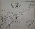
COLLINS, Captain Greenville
(P. of Carnarvan Shire/ P. of the Isle of Anglesey)
Imprint: London, c.1720
565 x 445 mm, on double backed paper as issued, in good condition.
From the magnificent and important 'Great Britain's Coasting Pilot'. This was the first accurate sea survey domestically published. This fine chart displays the Menai Straits between the island of Anglesey and mainland Wales. Evans, Olwen Caradoc. (1969). Marine Plans and Charts of Wales, in Map Collectors Circle no. 54; Verner 'Captain Collins' 'Coasting Pilot'', in Map Collectors' Circle no. 58; Shirley BL M.Coll 1a no. 19.